Butte geodata
Butte (Alaska) is a populated place; located in United States in America/Anchorage (GMT-8) time zone. With population of 3,246 people, there are 9240 cities with bigger population in this country. Compared to other cities in United States, 99.7% of cities are located further ↓South; 99% of cities are located further →East and 84.4% of cities have higher elevation than Butte. Note1


Butte GPS coordinates[2]
61° 32' 31.992" North, 149° 1' 59.988" West
| Map corner | latitude | longitude |
|---|---|---|
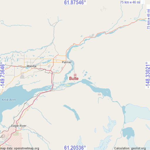
| Upper-left | 61.87546°, | -149.73646° |
| Center: | 61.54222°, | -149.03333° |
| Lower-right: | 61.20536°, | -148.33021° |
| Map W x H: | 74.5×74.5 km | = 46.3×46.3mi |
| max Lat: | 71.29058° ⇑0.3% North |
| Butte: | 61.54222° |
| min Lat: | ⇓99.7% South 19.06759° |
| min Long | Butte | max Long |
| -171.73463° | -149.03333° | -66.98998° |
| W 1%⇐ | ⇒99% E |
Elevation
Elevation of Butte is 30 m = 98 ft, and this is 264.8 m = 869 ft below average elevation for this country.
| Max E: |
3189 m = 10463 ft | 84.4% |
| Avg. | 294.8 m = 967 ft | |
| Butte | 30 m = 98 ft | |
Min E: |
-60 m = -197 ft | 15.6% |
See also: United States elevation on elevation.city.
Geographical zone
Butte is located in North temperate zone (between Tropic of Cancer and the Arctic Circle). Distance of this North polar circle is 558.3 km =346.9 mi to North.| Distance of | km | miles | from Butte |
|---|---|---|---|
| North Pole | 3164.2 | 1966.1 | to North |
| Arctic Circle | 558.3 | 346.9 | to North |
| Tropic Cancer | 4236.9 | 2632.7 | to South |
| Equator | 6842.9 | 4252 | to South |


Nearby cities:
15 places around Butte: (largest is in red/bold)
• Buffalo Soapstone
19.7 km =12.2 mi,  349°
349°
• Eagle River
37.6 km =23.4 mi,  229°
229°
• Farm Loop
12.2 km =7.6 mi,  331°
331°
• Fishhook
24.9 km =15.5 mi, 334°
• Gateway
11.5 km =7.1 mi,  287°
287°
• Houston
42.7 km =26.5 mi,  283°
283°
• Knik River
11.2 km =7 mi,  144°
144°
• Knik-Fairview
30.2 km =18.8 mi,  263°
263°
• Lakes
16.3 km =10.1 mi,  296°
296°
• Lazy Mountain
10.4 km =6.5 mi,  26°
26°
• Meadow Lakes
31.4 km =19.5 mi, 286°
• Palmer
7.7 km =4.8 mi, 325°
• Sutton-Alpine
29.8 km =18.5 mi, 28°
• Tanaina
22.9 km =14.2 mi, 294°
• Wasilla
22 km =13.7 mi, 281°
Sources, notices
• [Note1] Compared only with cities in United States existing in our database
• [Src1] Map data: © OpenStreetMap contributors (CC-BY-SA)
• [Src2] Other city data from geonames.org with taken over terms of usage.
• [Src3] Geographical zone / Annual Mean Temperature by Robert A. Rohde @ Wikipedia
