Owens Cross Roads geodata
Owens Cross Roads (Alabama) is a populated place; located in United States in America/Chicago (GMT-5) time zone. With population of 1,785 people, there are 12600 cities with bigger population in this country. Compared to other cities in United States, 77.3% of cities are located further ↑North; 51.7% of cities are located further ←West and 55.3% of cities have higher elevation than Owens Cross Roads. Note1


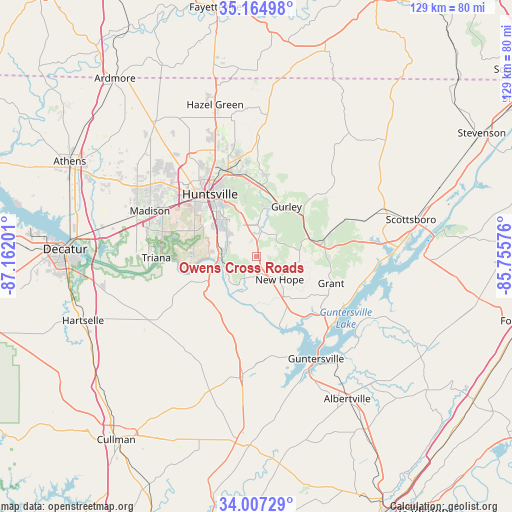
Owens Cross Roads GPS coordinates[2]
34° 35' 17.34" North, 86° 27' 31.968" West
| Map corner | latitude | longitude |
|---|---|---|
| Upper-left | 35.16498°, | -87.16201° |
| Center: | 34.58815°, | -86.45888° |
| Lower-right: | 34.00729°, | -85.75576° |
| Map W x H: | 128.7×128.7 km | = 80×80mi |
| max Lat: | 71.29058° ⇑77.3% North |
| Owens Cross Roads: | 34.58815° |
| min Lat: | ⇓22.7% South 19.06759° |
| min Long | Owens Cross Roa | max Long |
| -171.73463° | -86.45888° | -66.98998° |
| W 51.7%⇐ | ⇒48.3% E |
Elevation
Elevation of Owens Cross Roads is 179 m = 587 ft, and this is 115.8 m = 380 ft below average elevation for this country.
| Max E: |
3189 m = 10463 ft | 55.3% |
| Avg. | 294.8 m = 967 ft | |
| Owens Cross Roads | 179 m = 587 ft | |
Min E: |
-60 m = -197 ft | 44.7% |
See also: United States elevation on elevation.city.
Geographical zone
Owens Cross Roads is located in North temperate zone (between Tropic of Cancer and the Arctic Circle). Distance of this Northern Tropic circle is 1239.9 km =770.4 mi to South.| Distance of | km | miles | from Owens Cross Roads |
|---|---|---|---|
| North Pole | 6161.2 | 3828.4 | to North |
| Arctic Circle | 3555.3 | 2209.2 | to North |
| Tropic Cancer | 1239.9 | 770.4 | to South |
| Equator | 3845.8 | 2389.7 | to South |


Nearby cities:
15 places around Owens Cross Roads: (largest is in red/bold)
• Arab
30.2 km =18.8 mi,  186°
186°
• Grant
20 km =12.4 mi,  109°
109°
• Guntersville
29.7 km =18.5 mi,  149°
149°
• Gurley
14.7 km =9.1 mi,  31°
31°
• Huntsville
19.6 km =12.2 mi,  323°
323°
• Joppa
33.5 km =20.8 mi,  195°
195°
• Madison
29.2 km =18.1 mi,  295°
295°
• Meridianville
31.1 km =19.3 mi,  340°
340°
• Moores Mill
29 km =18 mi,  349°
349°
• New Hope
8.2 km =5.1 mi,  133°
133°
• New Market
35.9 km =22.3 mi,  4°
4°
• Redstone Arsenal
20.3 km =12.6 mi, 301°
• Somerville
33.6 km =20.9 mi,  247°
247°
• Triana
25.1 km =15.6 mi,  269°
269°
• Woodville
17.4 km =10.8 mi,  75°
75°
Sources, notices
• [Note1] Compared only with cities in United States existing in our database
• [Src1] Map data: © OpenStreetMap contributors (CC-BY-SA)
• [Src2] Other city data from geonames.org with taken over terms of usage.
• [Src3] Geographical zone / Annual Mean Temperature by Robert A. Rohde @ Wikipedia
