Holloman Air Force Base geodata
Holloman Air Force Base (New Mexico) is a populated place; located in United States in America/Denver (GMT-6) time zone. With population of 3,054 people, there are 9545 cities with bigger population in this country. Compared to other cities in United States, 85.7% of cities are located further ↑North; 84% of cities are located further →East and 94.9% of cities have lower elevation than Holloman Air Force Base. Note1
Current local time in Holloman Air Force Base:
05:26 AM, TuesdayDifference from your time zone: hours


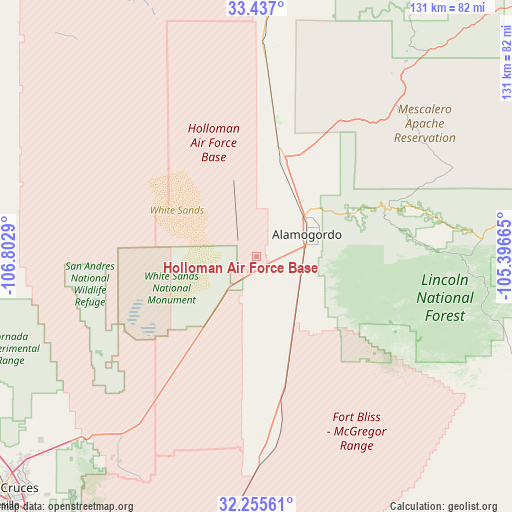
Holloman Air Force Base GPS coordinates[2]
32° 50' 53.772" North, 106° 5' 59.172" West
| Map corner | latitude | longitude |
|---|---|---|
| Upper-left | 33.437°, | -106.8029° |
| Center: | 32.84827°, | -106.09977° |
| Lower-right: | 32.25561°, | -105.39665° |
| Map W x H: | 131.4×131.4 km | = 81.6×81.6mi |
| max Lat: | 71.29058° ⇑85.7% North |
| Holloman Air Force Base: | 32.84827° |
| min Lat: | ⇓14.3% South 19.06759° |
| min Long | Holloman Air Fo | max Long |
| -171.73463° | -106.09977° | -66.98998° |
| W 16%⇐ | ⇒84% E |
Elevation
Elevation of Holloman Air Force Base is 1241 m = 4072 ft, and this is 946.2 m = 3104 ft above average elevation for this country.
| Max E: |
3189 m = 10463 ft | 5.1% |
| Holloman Air Force Base | 1241 m 4072 ft | |
| Avg. | 294.8 m = 967 ft | |
Min E: |
-60 m = -197 ft | 94.9% |
See also: United States elevation on elevation.city.
Geographical zone
Holloman Air Force Base is located in North temperate zone (between Tropic of Cancer and the Arctic Circle). Distance of this Northern Tropic circle is 1046.5 km =650.3 mi to South.| Distance of | km | miles | from Holloman Air Force Base |
|---|---|---|---|
| North Pole | 6354.7 | 3948.6 | to North |
| Arctic Circle | 3748.8 | 2329.4 | to North |
| Tropic Cancer | 1046.5 | 650.3 | to South |
| Equator | 3652.4 | 2269.5 | to South |


Nearby cities:
15 places around Holloman Air Force Base: (largest is in red/bold)
• Alamogordo
14.2 km =8.8 mi,  66°
66°
• Boles Acres
11.6 km =7.2 mi,  113°
113°
• Cloudcroft
35.5 km =22.1 mi, 70°
• Doña Ana
84.1 km =52.3 mi,  232°
232°
• High Rolls
27.2 km =16.9 mi, 65°
• La Luz
20.6 km =12.8 mi,  45°
45°
• Las Cruces
87.1 km =54.1 mi, 226°
• Mescalero
45.9 km =28.5 mi,  41°
41°
• Radium Springs
86.6 km =53.8 mi,  243°
243°
• Ruidoso
66.9 km =41.6 mi, 36°
• Ruidoso Downs
70.6 km =43.9 mi, 40°
• San Ysidro
86.6 km =53.8 mi, 230°
• Tularosa
26.2 km =16.3 mi,  16°
16°
• University Park
87.7 km =54.5 mi,  224°
224°
• White Sands
63 km =39.1 mi,  214°
214°
Sources, notices
• [Note1] Compared only with cities in United States existing in our database
• [Src1] Map data: © OpenStreetMap contributors (CC-BY-SA)
• [Src2] Other city data from geonames.org with taken over terms of usage.
• [Src3] Geographical zone / Annual Mean Temperature by Robert A. Rohde @ Wikipedia
