Tularosa geodata
Tularosa (New Mexico) is a populated place; located in United States in America/Denver (GMT-6) time zone. With population of 2,864 people, there are 9886 cities with bigger population in this country. Compared to other cities in United States, 84.9% of cities are located further ↑North; 83.9% of cities are located further →East and 95.8% of cities have lower elevation than Tularosa. Note1


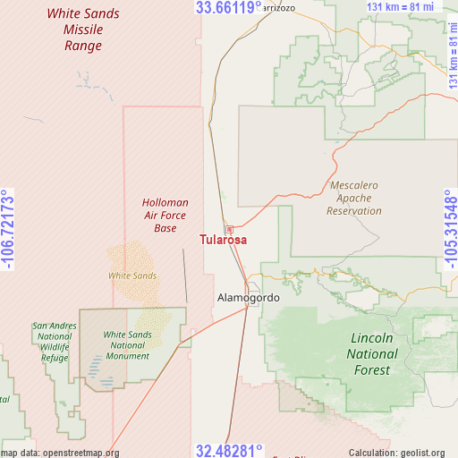
Tularosa GPS coordinates[2]
33° 4' 26.292" North, 106° 1' 6.96" West
| Map corner | latitude | longitude |
|---|---|---|
| Upper-left | 33.66119°, | -106.72173° |
| Center: | 33.07397°, | -106.0186° |
| Lower-right: | 32.48281°, | -105.31548° |
| Map W x H: | 131×131 km | = 81.4×81.4mi |
| max Lat: | 71.29058° ⇑84.9% North |
| Tularosa: | 33.07397° |
| min Lat: | ⇓15.1% South 19.06759° |
| min Long | Tularosa | max Long |
| -171.73463° | -106.0186° | -66.98998° |
| W 16.1%⇐ | ⇒83.9% E |
Elevation
Elevation of Tularosa is 1376 m = 4514 ft, and this is 1081.2 m = 3547 ft above average elevation for this country.
| Max E: |
3189 m = 10463 ft | 4.2% |
| Tularosa | 1376 m 4514 ft | |
| Avg. | 294.8 m = 967 ft | |
Min E: |
-60 m = -197 ft | 95.8% |
See also: United States elevation on elevation.city.
Geographical zone
Tularosa is located in North temperate zone (between Tropic of Cancer and the Arctic Circle). Distance of this Northern Tropic circle is 1071.6 km =665.9 mi to South.| Distance of | km | miles | from Tularosa |
|---|---|---|---|
| North Pole | 6329.6 | 3933 | to North |
| Arctic Circle | 3723.7 | 2313.8 | to North |
| Tropic Cancer | 1071.6 | 665.9 | to South |
| Equator | 3677.5 | 2285.1 | to South |


Nearby cities:
15 places around Tularosa: (largest is in red/bold)
• Alamogordo
20.1 km =12.5 mi,  164°
164°
• Boles Acres
29.8 km =18.5 mi,  174°
174°
• Capitan
66.8 km =41.5 mi,  38°
38°
• Carrizozo
64.5 km =40.1 mi,  11°
11°
• Cloudcroft
28.8 km =17.9 mi,  116°
116°
• Doña Ana
106.4 km =66.1 mi,  224°
224°
• Elephant Butte
108.9 km =67.7 mi,  274°
274°
• High Rolls
21.9 km =13.6 mi,  128°
128°
• Holloman Air Force Base
26.2 km =16.3 mi,  196°
196°
• La Luz
12.9 km =8 mi,  146°
146°
• Mescalero
24.6 km =15.3 mi,  67°
67°
• Radium Springs
106.2 km =66 mi,  233°
233°
• Ruidoso
43.1 km =26.8 mi,  48°
48°
• Ruidoso Downs
47.8 km =29.7 mi, 53°
• White Sands
88.3 km =54.9 mi,  209°
209°
Sources, notices
• [Note1] Compared only with cities in United States existing in our database
• [Src1] Map data: © OpenStreetMap contributors (CC-BY-SA)
• [Src2] Other city data from geonames.org with taken over terms of usage.
• [Src3] Geographical zone / Annual Mean Temperature by Robert A. Rohde @ Wikipedia
