Oljato-Monument Valley geodata
Oljato-Monument Valley (Utah) is a populated place; located in United States in America/Denver (GMT-6) time zone. With population of 674 people, there are 18930 cities with bigger population in this country. Compared to other cities in United States, 66% of cities are located further ↑North; 85.9% of cities are located further →East and 98.3% of cities have lower elevation than Oljato-Monument Valley. Note1
Current local time in Oljato-Monument Valley:
01:53 AM, WednesdayDifference from your time zone: hours


Oljato-Monument Valley GPS coordinates[2]
37° 1' 50.088" North, 110° 15' 5.148" West
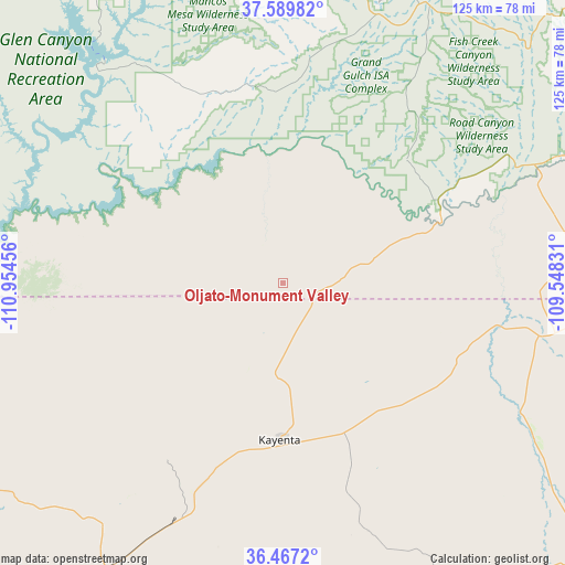
| Map corner | latitude | longitude |
|---|---|---|
| Upper-left | 37.58982°, | -110.95456° |
| Center: | 37.03058°, | -110.25143° |
| Lower-right: | 36.4672°, | -109.54831° |
| Map W x H: | 124.8×124.8 km | = 77.5×77.5mi |
| max Lat: | 71.29058° ⇑66% North |
| Oljato-Monument Valley: | 37.03058° |
| min Lat: | ⇓34% South 19.06759° |
| min Long | Oljato-Monument | max Long |
| -171.73463° | -110.25143° | -66.98998° |
| W 14.1%⇐ | ⇒85.9% E |
Elevation
Elevation of Oljato-Monument Valley is 1767 m = 5797 ft, and this is 1472.2 m = 4830 ft above average elevation for this country.
| Max E: |
3189 m = 10463 ft | 1.7% |
| Oljato-Monument Valley | 1767 m 5797 ft | |
| Avg. | 294.8 m = 967 ft | |
Min E: |
-60 m = -197 ft | 98.3% |
See also: United States elevation on elevation.city.
Geographical zone
Oljato-Monument Valley is located in North temperate zone (between Tropic of Cancer and the Arctic Circle). Distance of this Northern Tropic circle is 1511.5 km =939.2 mi to South.| Distance of | km | miles | from Oljato-Monument Valley |
|---|---|---|---|
| North Pole | 5889.6 | 3659.6 | to North |
| Arctic Circle | 3283.8 | 2040.5 | to North |
| Tropic Cancer | 1511.5 | 939.2 | to South |
| Equator | 4117.4 | 2558.4 | to South |


Nearby cities:
15 places around Oljato-Monument Valley: (largest is in red/bold)
• Aneth
96.6 km =60 mi,  77°
77°
• Blanding
94.9 km =59 mi,  45°
45°
• Chilchinbito
58 km =36 mi,  164°
164°
• Dennehotso
41.4 km =25.7 mi,  119°
119°
• Kaibito
87.7 km =54.5 mi,  236°
236°
• Kayenta
33.7 km =20.9 mi,  180°
180°
• LeChee
107.3 km =66.7 mi,  259°
259°
• Many Farms
94.2 km =58.5 mi,  143°
143°
• Page
107.8 km =67 mi, 263°
• Pinon
103.4 km =64.2 mi, 178°
• Rock Point
65.6 km =40.8 mi, 121°
• Round Rock
90.1 km =56 mi,  129°
129°
• Shonto
59.7 km =37.1 mi,  215°
215°
• Teec Nos Pos
104.3 km =64.8 mi,  96°
96°
• Tonalea
101.1 km =62.8 mi, 218°
Sources, notices
• [Note1] Compared only with cities in United States existing in our database
• [Src1] Map data: © OpenStreetMap contributors (CC-BY-SA)
• [Src2] Other city data from geonames.org with taken over terms of usage.
• [Src3] Geographical zone / Annual Mean Temperature by Robert A. Rohde @ Wikipedia
