Kayenta geodata
Kayenta (Arizona) is a populated place; located in United States in America/Denver (GMT-6) time zone. With population of 5,189 people, there are 7014 cities with bigger population in this country. Compared to other cities in United States, 67.2% of cities are located further ↑North; 85.9% of cities are located further →East and 98% of cities have lower elevation than Kayenta. Note1


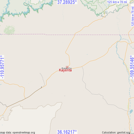
Kayenta GPS coordinates[2]
36° 43' 40.008" North, 110° 15' 16.488" West
| Map corner | latitude | longitude |
|---|---|---|
| Upper-left | 37.28925°, | -110.95771° |
| Center: | 36.72778°, | -110.25458° |
| Lower-right: | 36.16217°, | -109.55146° |
| Map W x H: | 125.3×125.3 km | = 77.9×77.9mi |
| max Lat: | 71.29058° ⇑67.2% North |
| Kayenta: | 36.72778° |
| min Lat: | ⇓32.8% South 19.06759° |
| min Long | Kayenta | max Long |
| -171.73463° | -110.25458° | -66.98998° |
| W 14.1%⇐ | ⇒85.9% E |
Elevation
Elevation of Kayenta is 1721 m = 5646 ft, and this is 1426.2 m = 4679 ft above average elevation for this country.
| Max E: |
3189 m = 10463 ft | 2% |
| Kayenta | 1721 m 5646 ft | |
| Avg. | 294.8 m = 967 ft | |
Min E: |
-60 m = -197 ft | 98% |
See also: United States elevation on elevation.city.
Geographical zone
Kayenta is located in North temperate zone (between Tropic of Cancer and the Arctic Circle). Distance of this Northern Tropic circle is 1477.8 km =918.3 mi to South.| Distance of | km | miles | from Kayenta |
|---|---|---|---|
| North Pole | 5923.3 | 3680.6 | to North |
| Arctic Circle | 3317.4 | 2061.3 | to North |
| Tropic Cancer | 1477.8 | 918.3 | to South |
| Equator | 4083.7 | 2537.5 | to South |


Nearby cities:
15 places around Kayenta: (largest is in red/bold)
• Chilchinbito
27.1 km =16.8 mi,  145°
145°
• Chinle
89.5 km =55.6 mi,  135°
135°
• Dennehotso
38.6 km =24 mi,  70°
70°
• First Mesa
99.7 km =62 mi,  186°
186°
• Hotevilla-Bacavi
96.5 km =60 mi,  202°
202°
• Kaibito
74.5 km =46.3 mi,  258°
258°
• Low Mountain
88.5 km =55 mi,  171°
171°
• Lukachukai
97.9 km =60.8 mi,  110°
110°
• Many Farms
70.5 km =43.8 mi,  126°
126°
• Oljato-Monument Valley
33.7 km =20.9 mi,  0°
0°
• Pinon
69.8 km =43.4 mi,  177°
177°
• Rock Point
56 km =34.8 mi,  91°
91°
• Round Rock
73.7 km =45.8 mi, 108°
• Shonto
37.6 km =23.4 mi,  246°
246°
• Tonalea
77.7 km =48.3 mi,  234°
234°
Sources, notices
• [Note1] Compared only with cities in United States existing in our database
• [Src1] Map data: © OpenStreetMap contributors (CC-BY-SA)
• [Src2] Other city data from geonames.org with taken over terms of usage.
• [Src3] Geographical zone / Annual Mean Temperature by Robert A. Rohde @ Wikipedia
