Fishhook geodata
Fishhook (Alaska) is a populated place; located in United States in America/Anchorage (GMT-8) time zone. With population of 4,679 people, there are 7458 cities with bigger population in this country. Compared to other cities in United States, 99.8% of cities are located further ↓South; 99% of cities are located further →East and 85.5% of cities have lower elevation than Fishhook. Note1


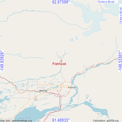
Fishhook GPS coordinates[2]
61° 44' 38.472" North, 149° 14' 10.068" West
| Map corner | latitude | longitude |
|---|---|---|
| Upper-left | 62.07509°, | -149.93926° |
| Center: | 61.74402°, | -149.23613° |
| Lower-right: | 61.40935°, | -148.53301° |
| Map W x H: | 74×74 km | = 46×46mi |
| max Lat: | 71.29058° ⇑0.2% North |
| Fishhook: | 61.74402° |
| min Lat: | ⇓99.8% South 19.06759° |
| min Long | Fishhook | max Long |
| -171.73463° | -149.23613° | -66.98998° |
| W 1%⇐ | ⇒99% E |
Elevation
Elevation of Fishhook is 434 m = 1424 ft, and this is 139.2 m = 457 ft above average elevation for this country.
| Max E: |
3189 m = 10463 ft | 14.5% |
| Fishhook | 434 m 1424 ft | |
| Avg. | 294.8 m = 967 ft | |
Min E: |
-60 m = -197 ft | 85.5% |
See also: United States elevation on elevation.city.
Geographical zone
Fishhook is located in North temperate zone (between Tropic of Cancer and the Arctic Circle). Distance of this North polar circle is 535.9 km =333 mi to North.| Distance of | km | miles | from Fishhook |
|---|---|---|---|
| North Pole | 3141.8 | 1952.2 | to North |
| Arctic Circle | 535.9 | 333 | to North |
| Tropic Cancer | 4259.4 | 2646.7 | to South |
| Equator | 6865.3 | 4265.9 | to South |


Nearby cities:
15 places around Fishhook: (largest is in red/bold)
• Buffalo Soapstone
7.8 km =4.8 mi,  113°
113°
• Butte
24.9 km =15.5 mi,  154°
154°
• Farm Loop
12.7 km =7.9 mi,  157°
157°
• Gateway
19 km =11.8 mi,  180°
180°
• Houston
33.2 km =20.6 mi,  247°
247°
• Knik River
35.9 km =22.3 mi, 151°
• Knik-Fairview
32.1 km =19.9 mi,  216°
216°
• Lakes
15.7 km =9.8 mi,  194°
194°
• Lazy Mountain
20.2 km =12.6 mi,  130°
130°
• Meadow Lakes
23.4 km =14.5 mi,  235°
235°
• Palmer
17.3 km =10.7 mi, 158°
• Sutton-Alpine
25.1 km =15.6 mi,  81°
81°
• Tanaina
16.5 km =10.3 mi, 217°
• Wasilla
21.1 km =13.1 mi,  210°
210°
• Willow
42.2 km =26.2 mi,  270°
270°
Sources, notices
• [Note1] Compared only with cities in United States existing in our database
• [Src1] Map data: © OpenStreetMap contributors (CC-BY-SA)
• [Src2] Other city data from geonames.org with taken over terms of usage.
• [Src3] Geographical zone / Annual Mean Temperature by Robert A. Rohde @ Wikipedia
