Trinidad geodata
Trinidad (Flores) is a seat of a first-order administrative division; located in Uruguay in America/Montevideo (GMT-3) time zone. With population of 21,429 people, there are 21 cities with bigger population in this country. Compared to other cities in Uruguay, 61.5% of cities are located further ↓South; 72.1% of cities are located further →East and 87.7% of cities have lower elevation than Trinidad. Note1


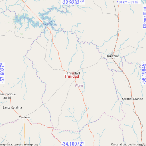
Trinidad GPS coordinates[2]
33° 30' 59.4" South, 56° 53' 58.452" West
| Map corner | latitude | longitude |
|---|---|---|
| Upper-left | -32.92831°, | -57.6027° |
| Center: | -33.5165°, | -56.89957° |
| Lower-right: | -34.10072°, | -56.19645° |
| Map W x H: | 130.4×130.4 km | = 81×81mi |
| max Lat: | -30.25966° ⇑38.5% North |
| Trinidad: | -33.5165° |
| min Lat: | ⇓61.5% South -34.94747° |
| min Long | Trinidad | max Long |
| -58.41176° | -56.89957° | -53.38583° |
| W 27.9%⇐ | ⇒72.1% E |
Elevation
Elevation of Trinidad is 142 m = 466 ft, and this is 71.4 m = 234 ft above average elevation for this country.
| Max E: |
294 m = 965 ft | 12.3% |
| Trinidad | 142 m 466 ft | |
| Avg. | 70.6 m = 232 ft | |
Min E: |
2 m = 7 ft | 87.7% |
See also: Uruguay elevation on elevation.city.
Geographical zone
Trinidad is located in South temperate zone (between Tropic of Capricorn and the Antarctic Circle). Distance of this Southern Tropic circle is 1120.8 km =696.4 mi to North.| Distance of | km | miles | from Trinidad |
|---|---|---|---|
| Equator | 3726.7 | 2315.7 | to North |
| Tropic Capricorn | 1120.8 | 696.4 | to North |
| Antarctic Circle | 3674.5 | 2283.2 | to South |
| South Pole | 6280.4 | 3902.5 | to South |


Nearby cities:
15 places around Trinidad: (largest is in red/bold)
• 25 de Mayo
90.9 km =56.5 mi,  145°
145°
• Cardona
58.6 km =36.4 mi,  227°
227°
• Carlos Reyles
64.5 km =40.1 mi,  37°
37°
• Durazno
38 km =23.6 mi,  66°
66°
• Florencio Sánchez
59.3 km =36.8 mi, 227°
• Florida
90.3 km =56.1 mi,  135°
135°
• José Enrique Rodó
61.8 km =38.4 mi,  251°
251°
• Nueva Helvecia
92.4 km =57.4 mi,  199°
199°
• Palmitas
83.6 km =51.9 mi,  270°
270°
• Paso de los Toros
85.6 km =53.2 mi,  24°
24°
• San José de Mayo
92.9 km =57.7 mi,  169°
169°
• Santa Bernardina
39.2 km =24.4 mi,  62°
62°
• Santa Catalina
62.5 km =38.8 mi,  240°
240°
• Sarandí Grande
57.7 km =35.9 mi,  114°
114°
• Villa del Carmen
88.2 km =54.8 mi, 69°
Sources, notices
• [Note1] Compared only with cities in Uruguay existing in our database
• [Src1] Map data: © OpenStreetMap contributors (CC-BY-SA)
• [Src2] Other city data from geonames.org with taken over terms of usage.
• [Src3] Geographical zone / Annual Mean Temperature by Robert A. Rohde @ Wikipedia
