Florida geodata
Florida is a seat of a first-order administrative division; located in Uruguay in America/Montevideo (GMT-3) time zone. With population of 32,234 people, there are 13 cities with bigger population in this country. Compared to other cities in Uruguay, 51.6% of cities are located further ↑North; 50.8% of cities are located further →East and 64.8% of cities have lower elevation than Florida. Note1


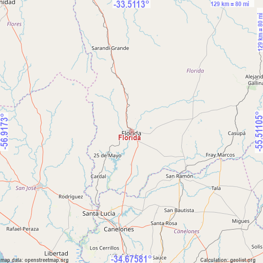
Florida GPS coordinates[2]
34° 5' 44.016" South, 56° 12' 51.012" West
| Map corner | latitude | longitude |
|---|---|---|
| Upper-left | -33.5113°, | -56.9173° |
| Center: | -34.09556°, | -56.21417° |
| Lower-right: | -34.67581°, | -55.51105° |
| Map W x H: | 129.5×129.5 km | = 80.5×80.5mi |
| max Lat: | -30.25966° ⇑51.6% North |
| Florida: | -34.09556° |
| min Lat: | ⇓48.4% South -34.94747° |
| min Long | Florida | max Long |
| -58.41176° | -56.21417° | -53.38583° |
| W 49.2%⇐ | ⇒50.8% E |
Elevation
Elevation of Florida is 74 m = 243 ft, and this is 3.4 m = 11 ft above average elevation for this country.
| Max E: |
294 m = 965 ft | 35.2% |
| Florida | 74 m 243 ft | |
| Avg. | 70.6 m = 232 ft | |
Min E: |
2 m = 7 ft | 64.8% |
See also: Uruguay elevation on elevation.city.
Geographical zone
Florida is located in South temperate zone (between Tropic of Capricorn and the Antarctic Circle). Distance of this Southern Tropic circle is 1185.2 km =736.4 mi to North.| Distance of | km | miles | from Florida |
|---|---|---|---|
| Equator | 3791.1 | 2355.7 | to North |
| Tropic Capricorn | 1185.2 | 736.4 | to North |
| Antarctic Circle | 3610.1 | 2243.2 | to South |
| South Pole | 6216 | 3862.4 | to South |


Nearby cities:
15 places around Florida: (largest is in red/bold)
• 25 de Agosto
39.2 km =24.4 mi,  206°
206°
• 25 de Mayo
15.5 km =9.6 mi,  227°
227°
• Aguas Corrientes
50.2 km =31.2 mi,  199°
199°
• Canelones
47.9 km =29.8 mi,  187°
187°
• Cardal
27 km =16.8 mi,  216°
216°
• Casupá
52.1 km =32.4 mi,  90°
90°
• Rodríguez
43.5 km =27 mi, 223°
• San Antonio
41.4 km =25.7 mi,  162°
162°
• San Bautista
44.9 km =27.9 mi,  148°
148°
• San José de Mayo
53.2 km =33.1 mi,  239°
239°
• San Ramón
32.2 km =20 mi,  132°
132°
• Santa Lucía
43 km =26.7 mi, 202°
• Santa Rosa
47.6 km =29.6 mi, 160°
• Sarandí Grande
41.8 km =26 mi,  344°
344°
• Tala
49.7 km =30.9 mi,  123°
123°
Sources, notices
• [Note1] Compared only with cities in Uruguay existing in our database
• [Src1] Map data: © OpenStreetMap contributors (CC-BY-SA)
• [Src2] Other city data from geonames.org with taken over terms of usage.
• [Src3] Geographical zone / Annual Mean Temperature by Robert A. Rohde @ Wikipedia
