Cardona geodata
Cardona (Soriano) is a populated place; located in Uruguay in America/Montevideo (GMT-3) time zone. With population of 4,712 people, there are 57 cities with bigger population in this country. Compared to other cities in Uruguay, 53.3% of cities are located further ↓South; 77% of cities are located further →East and 92.6% of cities have lower elevation than Cardona. Note1


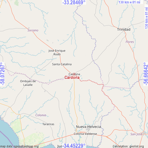
Cardona GPS coordinates[2]
33° 52' 13.764" South, 57° 22' 10.344" West
| Map corner | latitude | longitude |
|---|---|---|
| Upper-left | -33.28469°, | -58.07267° |
| Center: | -33.87049°, | -57.36954° |
| Lower-right: | -34.45229°, | -56.66642° |
| Map W x H: | 129.8×129.8 km | = 80.7×80.7mi |
| max Lat: | -30.25966° ⇑46.7% North |
| Cardona: | -33.87049° |
| min Lat: | ⇓53.3% South -34.94747° |
| min Long | Cardona | max Long |
| -58.41176° | -57.36954° | -53.38583° |
| W 23%⇐ | ⇒77% E |
Elevation
Elevation of Cardona is 170 m = 558 ft, and this is 99.4 m = 326 ft above average elevation for this country.
| Max E: |
294 m = 965 ft | 7.4% |
| Cardona | 170 m 558 ft | |
| Avg. | 70.6 m = 232 ft | |
Min E: |
2 m = 7 ft | 92.6% |
See also: Uruguay elevation on elevation.city.
Geographical zone
Cardona is located in South temperate zone (between Tropic of Capricorn and the Antarctic Circle). Distance of this Southern Tropic circle is 1160.1 km =720.9 mi to North.| Distance of | km | miles | from Cardona |
|---|---|---|---|
| Equator | 3766 | 2340.1 | to North |
| Tropic Capricorn | 1160.1 | 720.9 | to North |
| Antarctic Circle | 3635.1 | 2258.7 | to South |
| South Pole | 6241 | 3878 | to South |


Nearby cities:
15 places around Cardona: (largest is in red/bold)
• Carmelo
85.6 km =53.2 mi,  260°
260°
• Colonia del Sacramento
78.8 km =49 mi,  213°
213°
• Dolores
87.1 km =54.1 mi,  295°
295°
• Ecilda Paullier
61.7 km =38.3 mi,  151°
151°
• Florencio Sánchez
0.8 km =0.5 mi,  193°
193°
• José Enrique Rodó
24.5 km =15.2 mi,  322°
322°
• Juan L. Lacaze
61.5 km =38.2 mi, 187°
• Nueva Helvecia
49.4 km =30.7 mi,  165°
165°
• Ombúes de Lavalle
41.3 km =25.7 mi, 259°
• Palmitas
56.8 km =35.3 mi, 315°
• Rosario
49.6 km =30.8 mi,  177°
177°
• San José de Mayo
79.6 km =49.5 mi,  130°
130°
• Santa Catalina
14.1 km =8.8 mi,  308°
308°
• Tarariras
49.6 km =30.8 mi, 207°
• Trinidad
58.6 km =36.4 mi,  47°
47°
Sources, notices
• [Note1] Compared only with cities in Uruguay existing in our database
• [Src1] Map data: © OpenStreetMap contributors (CC-BY-SA)
• [Src2] Other city data from geonames.org with taken over terms of usage.
• [Src3] Geographical zone / Annual Mean Temperature by Robert A. Rohde @ Wikipedia
