Rosario geodata
Rosario (Colonia) is a populated place; located in Uruguay in America/Montevideo (GMT-3) time zone. With population of 9,308 people, there are 39 cities with bigger population in this country. Compared to other cities in Uruguay, 59% of cities are located further ↑North; 76.2% of cities are located further →East and 73% of cities have higher elevation than Rosario. Note1


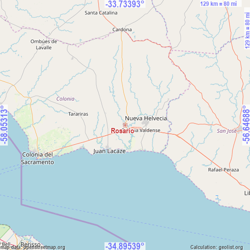
Rosario GPS coordinates[2]
34° 19' 0.012" South, 57° 21' 0" West
| Map corner | latitude | longitude |
|---|---|---|
| Upper-left | -33.73393°, | -58.05313° |
| Center: | -34.31667°, | -57.35° |
| Lower-right: | -34.89539°, | -56.64688° |
| Map W x H: | 129.1×129.1 km | = 80.2×80.2mi |
| max Lat: | -30.25966° ⇑59% North |
| Rosario: | -34.31667° |
| min Lat: | ⇓41% South -34.94747° |
| min Long | Rosario | max Long |
| -58.41176° | -57.35° | -53.38583° |
| W 23.8%⇐ | ⇒76.2% E |
Elevation
Elevation of Rosario is 26 m = 85 ft, and this is 44.6 m = 146 ft below average elevation for this country.
| Max E: |
294 m = 965 ft | 73% |
| Avg. | 70.6 m = 232 ft | |
| Rosario | 26 m = 85 ft | |
Min E: |
2 m = 7 ft | 27% |
See also: Uruguay elevation on elevation.city.
Geographical zone
Rosario is located in South temperate zone (between Tropic of Capricorn and the Antarctic Circle). Distance of this Southern Tropic circle is 1209.7 km =751.7 mi to North.| Distance of | km | miles | from Rosario |
|---|---|---|---|
| Equator | 3815.7 | 2371 | to North |
| Tropic Capricorn | 1209.7 | 751.7 | to North |
| Antarctic Circle | 3585.5 | 2227.9 | to South |
| South Pole | 6191.4 | 3847.2 | to South |


Nearby cities:
15 places around Rosario: (largest is in red/bold)
• Cardona
49.6 km =30.8 mi,  357°
357°
• Colonia del Sacramento
47.8 km =29.7 mi,  250°
250°
• Ecilda Paullier
28 km =17.4 mi,  99°
99°
• Florencio Sánchez
48.8 km =30.3 mi, 357°
• José Enrique Rodó
71 km =44.1 mi,  346°
346°
• Juan L. Lacaze
14.8 km =9.2 mi,  219°
219°
• Libertad
75.9 km =47.2 mi,  117°
117°
• Nueva Helvecia
10.9 km =6.8 mi,  80°
80°
• Ombúes de Lavalle
59.7 km =37.1 mi,  314°
314°
• Puntas de Valdéz
66.6 km =41.4 mi, 116°
• Rafael Perazza
55.7 km =34.6 mi,  114°
114°
• Rodríguez
74.9 km =46.5 mi, 95°
• San José de Mayo
58.5 km =36.4 mi,  92°
92°
• Santa Catalina
59.8 km =37.2 mi, 347°
• Tarariras
25.3 km =15.7 mi,  282°
282°
Sources, notices
• [Note1] Compared only with cities in Uruguay existing in our database
• [Src1] Map data: © OpenStreetMap contributors (CC-BY-SA)
• [Src2] Other city data from geonames.org with taken over terms of usage.
• [Src3] Geographical zone / Annual Mean Temperature by Robert A. Rohde @ Wikipedia
