Rodríguez geodata
Rodríguez (San José) is a populated place; located in Uruguay in America/Montevideo (GMT-3) time zone. With population of 2,588 people, there are 76 cities with bigger population in this country. Compared to other cities in Uruguay, 63.1% of cities are located further ↑North; 68% of cities are located further →East and 54.9% of cities have higher elevation than Rodríguez. Note1


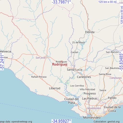
Rodríguez GPS coordinates[2]
34° 22' 51.6" South, 56° 32' 16.692" West
| Map corner | latitude | longitude |
|---|---|---|
| Upper-left | -33.79871°, | -57.2411° |
| Center: | -34.381°, | -56.53797° |
| Lower-right: | -34.95927°, | -55.83485° |
| Map W x H: | 129×129 km | = 80.2×80.2mi |
| max Lat: | -30.25966° ⇑63.1% North |
| Rodríguez: | -34.381° |
| min Lat: | ⇓36.9% South -34.94747° |
| min Long | Rodríguez | max Long |
| -58.41176° | -56.53797° | -53.38583° |
| W 32%⇐ | ⇒68% E |
Elevation
Elevation of Rodríguez is 48 m = 157 ft, and this is 22.6 m = 74 ft below average elevation for this country.
| Max E: |
294 m = 965 ft | 54.9% |
| Avg. | 70.6 m = 232 ft | |
| Rodríguez | 48 m = 157 ft | |
Min E: |
2 m = 7 ft | 45.1% |
See also: Uruguay elevation on elevation.city.
Geographical zone
Rodríguez is located in South temperate zone (between Tropic of Capricorn and the Antarctic Circle). Distance of this Southern Tropic circle is 1216.9 km =756.1 mi to North.| Distance of | km | miles | from Rodríguez |
|---|---|---|---|
| Equator | 3822.8 | 2375.4 | to North |
| Tropic Capricorn | 1216.9 | 756.1 | to North |
| Antarctic Circle | 3578.4 | 2223.5 | to South |
| South Pole | 6184.3 | 3842.7 | to South |


Nearby cities:
15 places around Rodríguez: (largest is in red/bold)
• 25 de Agosto
12.9 km =8 mi,  105°
105°
• 25 de Mayo
28.1 km =17.5 mi,  40°
40°
• Aguas Corrientes
20.5 km =12.7 mi,  139°
139°
• Canelones
28.6 km =17.8 mi,  123°
123°
• Cardal
17 km =10.6 mi,  53°
53°
• Florida
43.5 km =27 mi, 43°
• Juanicó
35.3 km =21.9 mi,  132°
132°
• Libertad
29.1 km =18.1 mi,  194°
194°
• Los Cerrillos
30 km =18.6 mi,  146°
146°
• Progreso
43.3 km =26.9 mi, 137°
• Puntas de Valdéz
27.2 km =16.9 mi,  213°
213°
• Rafael Perazza
28.5 km =17.7 mi,  236°
236°
• San Antonio
42.7 km =26.5 mi,  100°
100°
• San José de Mayo
16.8 km =10.4 mi,  286°
286°
• Santa Lucía
15.7 km =9.8 mi, 120°
Sources, notices
• [Note1] Compared only with cities in Uruguay existing in our database
• [Src1] Map data: © OpenStreetMap contributors (CC-BY-SA)
• [Src2] Other city data from geonames.org with taken over terms of usage.
• [Src3] Geographical zone / Annual Mean Temperature by Robert A. Rohde @ Wikipedia
