Juan L. Lacaze geodata
Juan L. Lacaze (Colonia) is a populated place; located in Uruguay in America/Montevideo (GMT-3) time zone. With population of 13,223 people, there are 32 cities with bigger population in this country. Compared to other cities in Uruguay, 64.8% of cities are located further ↑North; 79.5% of cities are located further →East and 86.1% of cities have higher elevation than Juan L. Lacaze. Note1


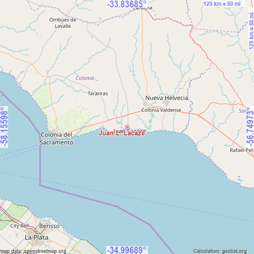
Juan L. Lacaze GPS coordinates[2]
34° 25' 7.968" South, 57° 27' 10.26" West
| Map corner | latitude | longitude |
|---|---|---|
| Upper-left | -33.83685°, | -58.15598° |
| Center: | -34.41888°, | -57.45285° |
| Lower-right: | -34.99689°, | -56.74973° |
| Map W x H: | 129×129 km | = 80.2×80.2mi |
| max Lat: | -30.25966° ⇑64.8% North |
| Juan L. Lacaze: | -34.41888° |
| min Lat: | ⇓35.2% South -34.94747° |
| min Long | Juan L. Lacaze | max Long |
| -58.41176° | -57.45285° | -53.38583° |
| W 20.5%⇐ | ⇒79.5% E |
Elevation
Elevation of Juan L. Lacaze is 15 m = 49 ft, and this is 55.6 m = 182 ft below average elevation for this country.
| Max E: |
294 m = 965 ft | 86.1% |
| Avg. | 70.6 m = 232 ft | |
| Juan L. Lacaze | 15 m = 49 ft | |
Min E: |
2 m = 7 ft | 13.9% |
See also: Uruguay elevation on elevation.city.
Geographical zone
Juan L. Lacaze is located in South temperate zone (between Tropic of Capricorn and the Antarctic Circle). Distance of this Southern Tropic circle is 1221.1 km =758.8 mi to North.| Distance of | km | miles | from Juan L. Lacaze |
|---|---|---|---|
| Equator | 3827 | 2378 | to North |
| Tropic Capricorn | 1221.1 | 758.8 | to North |
| Antarctic Circle | 3574.2 | 2220.9 | to South |
| South Pole | 6180 | 3840.1 | to South |


Nearby cities:
15 places around Juan L. Lacaze: (largest is in red/bold)
• Cardona
61.5 km =38.2 mi,  7°
7°
• Colonia del Sacramento
35.8 km =22.2 mi,  262°
262°
• Ecilda Paullier
37.7 km =23.4 mi,  79°
79°
• Florencio Sánchez
60.6 km =37.7 mi, 7°
• José Enrique Rodó
80.7 km =50.1 mi,  354°
354°
• Libertad
80.2 km =49.8 mi,  107°
107°
• Nueva Helvecia
24.1 km =15 mi,  56°
56°
• Ombúes de Lavalle
62.8 km =39 mi,  328°
328°
• Puntas de Valdéz
71.3 km =44.3 mi, 105°
• Rafael Perazza
61.2 km =38 mi,  100°
100°
• Rodríguez
84 km =52.2 mi,  87°
87°
• Rosario
14.8 km =9.2 mi,  39°
39°
• San José de Mayo
68.4 km =42.5 mi, 82°
• Santa Catalina
69.9 km =43.4 mi,  357°
357°
• Tarariras
22.9 km =14.2 mi,  318°
318°
Sources, notices
• [Note1] Compared only with cities in Uruguay existing in our database
• [Src1] Map data: © OpenStreetMap contributors (CC-BY-SA)
• [Src2] Other city data from geonames.org with taken over terms of usage.
• [Src3] Geographical zone / Annual Mean Temperature by Robert A. Rohde @ Wikipedia
