Pando geodata
Pando (Canelones) is a populated place; located in Uruguay in America/Montevideo (GMT-3) time zone. With population of 24,047 people, there are 18 cities with bigger population in this country. Compared to other cities in Uruguay, 83.6% of cities are located further ↑North; 61.5% of cities are located further ←West and 76.2% of cities have higher elevation than Pando. Note1


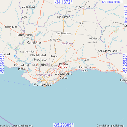
Pando GPS coordinates[2]
34° 43' 1.776" South, 55° 57' 30.24" West
| Map corner | latitude | longitude |
|---|---|---|
| Upper-left | -34.1372°, | -56.66153° |
| Center: | -34.71716°, | -55.9584° |
| Lower-right: | -35.29309°, | -55.25528° |
| Map W x H: | 128.5×128.5 km | = 79.8×79.8mi |
| max Lat: | -30.25966° ⇑83.6% North |
| Pando: | -34.71716° |
| min Lat: | ⇓16.4% South -34.94747° |
| min Long | Pando | max Long |
| -58.41176° | -55.9584° | -53.38583° |
| W 61.5%⇐ | ⇒38.5% E |
Elevation
Elevation of Pando is 23 m = 75 ft, and this is 47.6 m = 156 ft below average elevation for this country.
| Max E: |
294 m = 965 ft | 76.2% |
| Avg. | 70.6 m = 232 ft | |
| Pando | 23 m = 75 ft | |
Min E: |
2 m = 7 ft | 23.8% |
See also: Uruguay elevation on elevation.city.
Geographical zone
Pando is located in South temperate zone (between Tropic of Capricorn and the Antarctic Circle). Distance of this Southern Tropic circle is 1254.3 km =779.4 mi to North.| Distance of | km | miles | from Pando |
|---|---|---|---|
| Equator | 3860.2 | 2398.6 | to North |
| Tropic Capricorn | 1254.3 | 779.4 | to North |
| Antarctic Circle | 3541 | 2200.3 | to South |
| South Pole | 6146.9 | 3819.5 | to South |


Nearby cities:
15 places around Pando: (largest is in red/bold)
• Atlántida
19.3 km =12 mi,  108°
108°
• Barra de Carrasco
19 km =11.8 mi,  200°
200°
• Barros Blancos
5.6 km =3.5 mi,  225°
225°
• Colonia Nicolich
12.5 km =7.8 mi,  208°
208°
• Empalme Olmos
6.4 km =4 mi,  70°
70°
• Joaquín Suárez
7.2 km =4.5 mi,  254°
254°
• La Paz
24.9 km =15.5 mi,  258°
258°
• Las Piedras
23.9 km =14.9 mi,  266°
266°
• Las Toscas
22.2 km =13.8 mi,  94°
94°
• Paso de Carrasco
18.1 km =11.2 mi, 208°
• Progreso
24.3 km =15.1 mi,  283°
283°
• San Jacinto
20.8 km =12.9 mi,  22°
22°
• Sauce
12.1 km =7.5 mi,  306°
306°
• Soca
23.7 km =14.7 mi,  81°
81°
• Toledo
12.7 km =7.9 mi, 259°
Sources, notices
• [Note1] Compared only with cities in Uruguay existing in our database
• [Src1] Map data: © OpenStreetMap contributors (CC-BY-SA)
• [Src2] Other city data from geonames.org with taken over terms of usage.
• [Src3] Geographical zone / Annual Mean Temperature by Robert A. Rohde @ Wikipedia
