Sauce geodata
Sauce (Canelones) is a populated place; located in Uruguay in America/Montevideo (GMT-3) time zone. With population of 5,910 people, there are 52 cities with bigger population in this country. Compared to other cities in Uruguay, 79.5% of cities are located further ↑North; 53.3% of cities are located further ←West and 52.5% of cities have higher elevation than Sauce. Note1


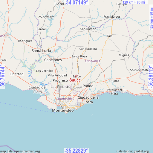
Sauce GPS coordinates[2]
34° 39' 6.876" South, 56° 3' 51.516" West
| Map corner | latitude | longitude |
|---|---|---|
| Upper-left | -34.07149°, | -56.76744° |
| Center: | -34.65191°, | -56.06431° |
| Lower-right: | -35.22829°, | -55.36119° |
| Map W x H: | 128.6×128.6 km | = 79.9×79.9mi |
| max Lat: | -30.25966° ⇑79.5% North |
| Sauce: | -34.65191° |
| min Lat: | ⇓20.5% South -34.94747° |
| min Long | Sauce | max Long |
| -58.41176° | -56.06431° | -53.38583° |
| W 53.3%⇐ | ⇒46.7% E |
Elevation
Elevation of Sauce is 52 m = 171 ft, and this is 18.6 m = 61 ft below average elevation for this country.
| Max E: |
294 m = 965 ft | 52.5% |
| Avg. | 70.6 m = 232 ft | |
| Sauce | 52 m = 171 ft | |
Min E: |
2 m = 7 ft | 47.5% |
See also: Uruguay elevation on elevation.city.
Geographical zone
Sauce is located in South temperate zone (between Tropic of Capricorn and the Antarctic Circle). Distance of this Southern Tropic circle is 1247 km =774.8 mi to North.| Distance of | km | miles | from Sauce |
|---|---|---|---|
| Equator | 3852.9 | 2394.1 | to North |
| Tropic Capricorn | 1247 | 774.8 | to North |
| Antarctic Circle | 3548.2 | 2204.7 | to South |
| South Pole | 6154.1 | 3824 | to South |


Nearby cities:
15 places around Sauce: (largest is in red/bold)
• Barros Blancos
12.5 km =7.8 mi,  153°
153°
• Canelones
24.2 km =15 mi,  306°
306°
• Colonia Nicolich
18.5 km =11.5 mi,  168°
168°
• Empalme Olmos
16.5 km =10.3 mi,  107°
107°
• Joaquín Suárez
9.6 km =6 mi,  163°
163°
• Juanicó
18.4 km =11.4 mi,  290°
290°
• La Paz
19.1 km =11.9 mi,  230°
230°
• Las Piedras
16.6 km =10.3 mi,  238°
238°
• Pando
12.1 km =7.5 mi,  126°
126°
• Paso de Carrasco
23.2 km =14.4 mi,  177°
177°
• Progreso
14.1 km =8.8 mi,  263°
263°
• San Antonio
22.4 km =13.9 mi,  356°
356°
• San Jacinto
21.3 km =13.2 mi,  55°
55°
• Santa Rosa
17.3 km =10.7 mi,  8°
8°
• Toledo
10 km =6.2 mi,  196°
196°
Sources, notices
• [Note1] Compared only with cities in Uruguay existing in our database
• [Src1] Map data: © OpenStreetMap contributors (CC-BY-SA)
• [Src2] Other city data from geonames.org with taken over terms of usage.
• [Src3] Geographical zone / Annual Mean Temperature by Robert A. Rohde @ Wikipedia
