Joaquín Suárez geodata
Joaquín Suárez (Canelones) is a populated place; located in Uruguay in America/Montevideo (GMT-3) time zone. With population of 6,257 people, there are 50 cities with bigger population in this country. Compared to other cities in Uruguay, 86.1% of cities are located further ↑North; 55.7% of cities are located further ←West and 55.7% of cities have lower elevation than Joaquín Suárez. Note1


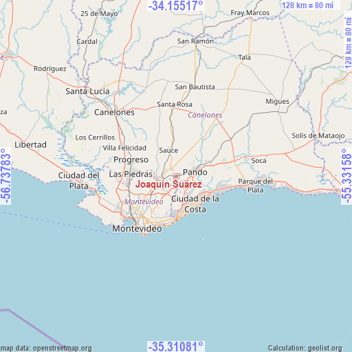
Joaquín Suárez GPS coordinates[2]
34° 44' 6.036" South, 56° 2' 4.92" West
| Map corner | latitude | longitude |
|---|---|---|
| Upper-left | -34.15517°, | -56.73783° |
| Center: | -34.73501°, | -56.0347° |
| Lower-right: | -35.31081°, | -55.33158° |
| Map W x H: | 128.5×128.5 km | = 79.8×79.8mi |
| max Lat: | -30.25966° ⇑86.1% North |
| Joaquín Suárez: | -34.73501° |
| min Lat: | ⇓13.9% South -34.94747° |
| min Long | Joaquín Suáre | max Long |
| -58.41176° | -56.0347° | -53.38583° |
| W 55.7%⇐ | ⇒44.3% E |
Elevation
Elevation of Joaquín Suárez is 58 m = 190 ft, and this is 12.6 m = 41 ft below average elevation for this country.
| Max E: |
294 m = 965 ft | 44.3% |
| Avg. | 70.6 m = 232 ft | |
| Joaquín Suárez | 58 m = 190 ft | |
Min E: |
2 m = 7 ft | 55.7% |
See also: Uruguay elevation on elevation.city.
Geographical zone
Joaquín Suárez is located in South temperate zone (between Tropic of Capricorn and the Antarctic Circle). Distance of this Southern Tropic circle is 1256.3 km =780.6 mi to North.| Distance of | km | miles | from Joaquín Suárez |
|---|---|---|---|
| Equator | 3862.2 | 2399.9 | to North |
| Tropic Capricorn | 1256.3 | 780.6 | to North |
| Antarctic Circle | 3539 | 2199 | to South |
| South Pole | 6144.9 | 3818.3 | to South |


Nearby cities:
15 places around Joaquín Suárez: (largest is in red/bold)
• Atlántida
25.6 km =15.9 mi,  99°
99°
• Barra de Carrasco
15.8 km =9.8 mi,  178°
178°
• Barros Blancos
3.5 km =2.2 mi,  123°
123°
• Colonia Nicolich
9 km =5.6 mi,  173°
173°
• Empalme Olmos
13.6 km =8.5 mi,  72°
72°
• Juanicó
25.4 km =15.8 mi,  307°
307°
• La Paz
17.7 km =11 mi,  260°
260°
• Las Piedras
16.9 km =10.5 mi,  271°
271°
• Montevideo
23.4 km =14.5 mi,  216°
216°
• Pando
7.2 km =4.5 mi, 74°
• Paso de Carrasco
14 km =8.7 mi,  186°
186°
• Progreso
18.3 km =11.4 mi,  294°
294°
• San Jacinto
25.9 km =16.1 mi,  35°
35°
• Sauce
9.6 km =6 mi,  343°
343°
• Toledo
5.5 km =3.4 mi, 266°
Sources, notices
• [Note1] Compared only with cities in Uruguay existing in our database
• [Src1] Map data: © OpenStreetMap contributors (CC-BY-SA)
• [Src2] Other city data from geonames.org with taken over terms of usage.
• [Src3] Geographical zone / Annual Mean Temperature by Robert A. Rohde @ Wikipedia
