Atlántida geodata
Atlántida (Canelones) is a populated place; located in Uruguay in America/Montevideo (GMT-3) time zone. With population of 4,669 people, there are 58 cities with bigger population in this country. Compared to other cities in Uruguay, 91% of cities are located further ↑North; 65.6% of cities are located further ←West and 78.7% of cities have higher elevation than Atlántida. Note1


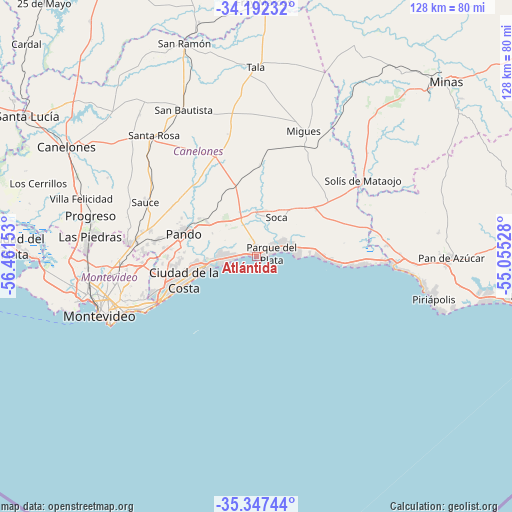
Atlántida GPS coordinates[2]
34° 46' 18.84" South, 55° 45' 30.24" West
| Map corner | latitude | longitude |
|---|---|---|
| Upper-left | -34.19232°, | -56.46153° |
| Center: | -34.7719°, | -55.7584° |
| Lower-right: | -35.34744°, | -55.05528° |
| Map W x H: | 128.4×128.4 km | = 79.8×79.8mi |
| max Lat: | -30.25966° ⇑91% North |
| Atlántida: | -34.7719° |
| min Lat: | ⇓9% South -34.94747° |
| min Long | Atlántida | max Long |
| -58.41176° | -55.7584° | -53.38583° |
| W 65.6%⇐ | ⇒34.4% E |
Elevation
Elevation of Atlántida is 22 m = 72 ft, and this is 48.6 m = 159 ft below average elevation for this country.
| Max E: |
294 m = 965 ft | 78.7% |
| Avg. | 70.6 m = 232 ft | |
| Atlántida | 22 m = 72 ft | |
Min E: |
2 m = 7 ft | 21.3% |
See also: Uruguay elevation on elevation.city.
Geographical zone
Atlántida is located in South temperate zone (between Tropic of Capricorn and the Antarctic Circle). Distance of this Southern Tropic circle is 1260.4 km =783.2 mi to North.| Distance of | km | miles | from Atlántida |
|---|---|---|---|
| Equator | 3866.3 | 2402.4 | to North |
| Tropic Capricorn | 1260.4 | 783.2 | to North |
| Antarctic Circle | 3534.9 | 2196.5 | to South |
| South Pole | 6140.8 | 3815.7 | to South |


Nearby cities:
15 places around Atlántida: (largest is in red/bold)
• Barra de Carrasco
27.4 km =17 mi,  244°
244°
• Barros Blancos
22.4 km =13.9 mi,  275°
275°
• Colonia Nicolich
24.8 km =15.4 mi,  258°
258°
• Empalme Olmos
14.8 km =9.2 mi,  303°
303°
• Joaquín Suárez
25.6 km =15.9 mi, 279°
• La Floresta
7.3 km =4.5 mi,  75°
75°
• Las Toscas
5.7 km =3.5 mi,  41°
41°
• Migues
33.8 km =21 mi,  20°
20°
• Pando
19.3 km =12 mi,  288°
288°
• Paso de Carrasco
28.6 km =17.8 mi,  249°
249°
• San Jacinto
27.3 km =17 mi,  337°
337°
• Sauce
31 km =19.3 mi, 295°
• Soca
11 km =6.8 mi,  27°
27°
• Solís de Mataojo
32.7 km =20.3 mi,  54°
54°
• Toledo
31 km =19.3 mi, 276°
Sources, notices
• [Note1] Compared only with cities in Uruguay existing in our database
• [Src1] Map data: © OpenStreetMap contributors (CC-BY-SA)
• [Src2] Other city data from geonames.org with taken over terms of usage.
• [Src3] Geographical zone / Annual Mean Temperature by Robert A. Rohde @ Wikipedia
