Solís de Mataojo geodata
Solís de Mataojo (Lavalleja) is a populated place; located in Uruguay in America/Montevideo (GMT-3) time zone. With population of 2,704 people, there are 72 cities with bigger population in this country. Compared to other cities in Uruguay, 77% of cities are located further ↑North; 77% of cities are located further ←West and 62.3% of cities have higher elevation than Solís de Mataojo. Note1


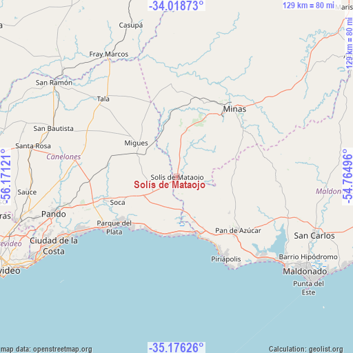
Solís de Mataojo GPS coordinates[2]
34° 35' 58.236" South, 55° 28' 5.088" West
| Map corner | latitude | longitude |
|---|---|---|
| Upper-left | -34.01873°, | -56.17121° |
| Center: | -34.59951°, | -55.46808° |
| Lower-right: | -35.17626°, | -54.76496° |
| Map W x H: | 128.7×128.7 km | = 80×80mi |
| max Lat: | -30.25966° ⇑77% North |
| Solís de Mataojo: | -34.59951° |
| min Lat: | ⇓23% South -34.94747° |
| min Long | Solís de Matao | max Long |
| -58.41176° | -55.46808° | -53.38583° |
| W 77%⇐ | ⇒23% E |
Elevation
Elevation of Solís de Mataojo is 40 m = 131 ft, and this is 30.6 m = 100 ft below average elevation for this country.
| Max E: |
294 m = 965 ft | 62.3% |
| Avg. | 70.6 m = 232 ft | |
| Solís de Mataojo | 40 m = 131 ft | |
Min E: |
2 m = 7 ft | 37.7% |
See also: Uruguay elevation on elevation.city.
Geographical zone
Solís de Mataojo is located in South temperate zone (between Tropic of Capricorn and the Antarctic Circle). Distance of this Southern Tropic circle is 1241.2 km =771.2 mi to North.| Distance of | km | miles | from Solís de Mataojo |
|---|---|---|---|
| Equator | 3847.1 | 2390.5 | to North |
| Tropic Capricorn | 1241.2 | 771.2 | to North |
| Antarctic Circle | 3554.1 | 2208.4 | to South |
| South Pole | 6160 | 3827.6 | to South |


Nearby cities:
15 places around Solís de Mataojo: (largest is in red/bold)
• Atlántida
32.7 km =20.3 mi,  234°
234°
• Barros Blancos
51.7 km =32.1 mi,  250°
250°
• Empalme Olmos
40.3 km =25 mi, 254°
• La Floresta
26.1 km =16.2 mi, 228°
• Las Toscas
27.2 km =16.9 mi,  236°
236°
• Migues
19.2 km =11.9 mi,  310°
310°
• Minas
32.6 km =20.3 mi,  40°
40°
• Montes
14.6 km =9.1 mi,  323°
323°
• Pan de Azúcar
29.1 km =18.1 mi,  133°
133°
• Pando
46.7 km =29 mi, 253°
• Piriápolis
34.2 km =21.3 mi,  148°
148°
• San Bautista
48.3 km =30 mi,  291°
291°
• San Jacinto
37.4 km =23.2 mi,  279°
279°
• Soca
23.4 km =14.5 mi, 246°
• Tala
39.3 km =24.4 mi, 316°
Sources, notices
• [Note1] Compared only with cities in Uruguay existing in our database
• [Src1] Map data: © OpenStreetMap contributors (CC-BY-SA)
• [Src2] Other city data from geonames.org with taken over terms of usage.
• [Src3] Geographical zone / Annual Mean Temperature by Robert A. Rohde @ Wikipedia
