Oltinko‘l geodata
Oltinko‘l (Karakalpakstan) is a populated place; located in Uzbekistan in Asia/Samarkand (GMT+5) time zone. With population of 59,122 people, there are 24 cities with bigger population in this country. Compared to other cities in Uzbekistan, 98.9% of cities are located further ↓South; 99.4% of cities are located further →East and 97.1% of cities have higher elevation than Oltinko‘l. Note1


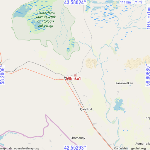
Oltinko‘l GPS coordinates[2]
43° 4' 7.464" North, 58° 54' 13.392" East
| Map corner | latitude | longitude |
|---|---|---|
| Upper-left | 43.58024°, | 58.2006° |
| Center: | 43.06874°, | 58.90372° |
| Lower-right: | 42.55293°, | 59.60685° |
| Map W x H: | 114.2×114.2 km | = 71×71mi |
| max Lat: | 43.77877° ⇑1.1% North |
| Oltinko‘l: | 43.06874° |
| min Lat: | ⇓98.9% South 37.22417° |
| min Long | Oltinko‘l | max Long |
| 58.84596° | 58.90372° | 72.76177° |
| W 0.6%⇐ | ⇒99.4% E |
Elevation
Elevation of Oltinko‘l is 63 m = 207 ft, and this is 370.8 m = 1217 ft below average elevation for this country.
| Max E: |
1464 m = 4803 ft | 97.1% |
| Avg. | 433.8 m = 1423 ft | |
| Oltinko‘l | 63 m = 207 ft | |
Min E: |
50 m = 164 ft | 2.9% |
See also: Oltinko‘l elevation on elevation.city.
Geographical zone
Oltinko‘l is located in North temperate zone (between Tropic of Cancer and the Arctic Circle). Distance of this Northern Tropic circle is 2182.9 km =1356.4 mi to South.| Distance of | km | miles | from Oltinko‘l |
|---|---|---|---|
| North Pole | 5218.3 | 3242.5 | to North |
| Arctic Circle | 2612.4 | 1623.3 | to North |
| Tropic Cancer | 2182.9 | 1356.4 | to South |
| Equator | 4788.8 | 2975.6 | to South |


Nearby cities:
15 places around Oltinko‘l: (largest is in red/bold)
• Chimboy Shahri
73.1 km =45.4 mi,  102°
102°
• Kegeyli Shahar
65.9 km =40.9 mi,  119°
119°
• Khŭjayli
87.1 km =54.1 mi,  148°
148°
• Mang‘it Shahri
141.7 km =88 mi,  137°
137°
• Mo‘ynoq Shahri
79.6 km =49.5 mi,  7°
7°
• Mŭynoq
78.4 km =48.7 mi, 6°
• Nukus
89.5 km =55.6 mi, 139°
• Oqmang‘it
73.3 km =45.5 mi, 135°
• Qanliko‘l
26.7 km =16.6 mi,  162°
162°
• Qorao‘zak
90.6 km =56.3 mi,  93°
93°
• Qozonketkan
37.8 km =23.5 mi, 98°
• Qo‘ng‘irot Shahri
5 km =3.1 mi,  248°
248°
• Shumanay Shahri
48.4 km =30.1 mi,  177°
177°
• Taxtako‘pir
113.7 km =70.6 mi, 93°
• Xo‘jayli Shahri
85.7 km =53.3 mi, 148°
Sources, notices
• [Note1] Compared only with cities in Uzbekistan existing in our database
• [Src1] Map data: © OpenStreetMap contributors (CC-BY-SA)
• [Src2] Other city data from geonames.org with taken over terms of usage.
• [Src3] Geographical zone / Annual Mean Temperature by Robert A. Rohde @ Wikipedia
