Mo‘ynoq Shahri geodata
Mo‘ynoq Shahri (Karakalpakstan) is a seat of a second-order administrative division; located in Uzbekistan in Asia/Samarkand (GMT+5) time zone. In our database, there are 114 cities with bigger population. Compared to other cities in Uzbekistan, 100% of cities are located further ↓South; 97.1% of cities are located further →East and 99.4% of cities have higher elevation than Mo‘ynoq Shahri. Note1


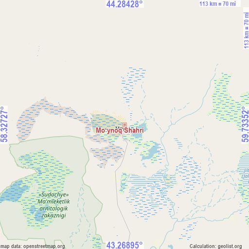
Mo‘ynoq Shahri GPS coordinates[2]
43° 46' 43.572" North, 59° 1' 49.404" East
| Map corner | latitude | longitude |
|---|---|---|
| Upper-left | 44.28428°, | 58.32727° |
| Center: | 43.77877°, | 59.03039° |
| Lower-right: | 43.26895°, | 59.73352° |
| Map W x H: | 112.9×112.9 km | = 70.2×70.2mi |
| max Lat: | 43.77877° ⇑0% North |
| Mo‘ynoq Shahri: | 43.77877° |
| min Lat: | ⇓100% South 37.22417° |
| min Long | Mo‘ynoq Shahr | max Long |
| 58.84596° | 59.03039° | 72.76177° |
| W 2.9%⇐ | ⇒97.1% E |
Elevation
Elevation of Mo‘ynoq Shahri is 57 m = 187 ft, and this is 376.8 m = 1236 ft below average elevation for this country.
| Max E: |
1464 m = 4803 ft | 99.4% |
| Avg. | 433.8 m = 1423 ft | |
| Mo‘ynoq Shahri | 57 m = 187 ft | |
Min E: |
50 m = 164 ft | 0.6% |
See also: Uzbekistan elevation on elevation.city.
Geographical zone
Mo‘ynoq Shahri is located in North temperate zone (between Tropic of Cancer and the Arctic Circle). Distance of this Northern Tropic circle is 2261.8 km =1405.4 mi to South.| Distance of | km | miles | from Mo‘ynoq Shahri |
|---|---|---|---|
| North Pole | 5139.3 | 3193.4 | to North |
| Arctic Circle | 2533.4 | 1574.2 | to North |
| Tropic Cancer | 2261.8 | 1405.4 | to South |
| Equator | 4867.7 | 3024.6 | to South |


Nearby cities:
15 places around Mo‘ynoq Shahri: (largest is in red/bold)
• Chimboy Shahri
112.3 km =69.8 mi,  147°
147°
• Kegeyli Shahar
120.8 km =75.1 mi,  157°
157°
• Khŭjayli
157.2 km =97.7 mi,  167°
167°
• Mang‘it Shahri
202.5 km =125.8 mi, 155°
• Mŭynoq
1.4 km =0.9 mi,  211°
211°
• Nukus
154.7 km =96.1 mi, 162°
• Oltinko‘l
79.6 km =49.5 mi,  187°
187°
• Oqmang‘it
137.4 km =85.4 mi, 162°
• Qanliko‘l
104.5 km =64.9 mi,  181°
181°
• Qorao‘zak
115.9 km =72 mi,  136°
136°
• Qozonketkan
88.7 km =55.1 mi, 162°
• Qo‘ng‘irot Shahri
82.2 km =51.1 mi, 190°
• Shumanay Shahri
127.5 km =79.2 mi, 183°
• Taxtako‘pir
133.5 km =83 mi,  129°
129°
• Xo‘jayli Shahri
156 km =96.9 mi, 167°
Sources, notices
• [Note1] Compared only with cities in Uzbekistan existing in our database
• [Src1] Map data: © OpenStreetMap contributors (CC-BY-SA)
• [Src2] Other city data from geonames.org with taken over terms of usage.
• [Src3] Geographical zone / Annual Mean Temperature by Robert A. Rohde @ Wikipedia
