Haqqulobod geodata
Haqqulobod (Namangan) is a populated place; located in Uzbekistan in Asia/Tashkent (GMT+5) time zone. With population of 26,257 people, there are 63 cities with bigger population in this country. Compared to other cities in Uzbekistan, 65.5% of cities are located further ↓South; 93.1% of cities are located further ←West and 52.9% of cities have lower elevation than Haqqulobod. Note1


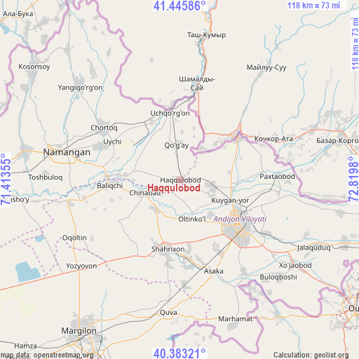
Haqqulobod GPS coordinates[2]
40° 55' 0.012" North, 72° 7' 0.012" East
| Map corner | latitude | longitude |
|---|---|---|
| Upper-left | 41.44586°, | 71.41355° |
| Center: | 40.91667°, | 72.11667° |
| Lower-right: | 40.38321°, | 72.8198° |
| Map W x H: | 118.2×118.2 km | = 73.4×73.4mi |
| max Lat: | 43.77877° ⇑34.5% North |
| Haqqulobod: | 40.91667° |
| min Lat: | ⇓65.5% South 37.22417° |
| min Long | Haqqulobod | max Long |
| 58.84596° | 72.11667° | 72.76177° |
| W 93.1%⇐ | ⇒6.9% E |
Elevation
Elevation of Haqqulobod is 438 m = 1437 ft, and this is 4.2 m = 14 ft above average elevation for this country.
| Max E: |
1464 m = 4803 ft | 47.1% |
| Haqqulobod | 438 m 1437 ft | |
| Avg. | 433.8 m = 1423 ft | |
Min E: |
50 m = 164 ft | 52.9% |
See also: Uzbekistan elevation on elevation.city.
Geographical zone
Haqqulobod is located in North temperate zone (between Tropic of Cancer and the Arctic Circle). Distance of this Northern Tropic circle is 1943.6 km =1207.7 mi to South.| Distance of | km | miles | from Haqqulobod |
|---|---|---|---|
| North Pole | 5457.6 | 3391.2 | to North |
| Arctic Circle | 2851.7 | 1772 | to North |
| Tropic Cancer | 1943.6 | 1207.7 | to South |
| Equator | 4549.5 | 2826.9 | to South |


Nearby cities:
15 places around Haqqulobod: (largest is in red/bold)
• Andijon
24.3 km =15.1 mi,  128°
128°
• Asaka
32.3 km =20.1 mi,  161°
161°
• Baliqchi
22.7 km =14.1 mi,  266°
266°
• Chortoq
29.9 km =18.6 mi,  304°
304°
• Chortoq Shahri
30.8 km =19.1 mi,  305°
305°
• Kuyganyor
17.5 km =10.9 mi,  113°
113°
• Namangan
38.4 km =23.9 mi,  283°
283°
• Oltinko‘l
13.7 km =8.5 mi, 159°
• Oqoltin
39.8 km =24.7 mi,  241°
241°
• Paxtaobod
32 km =19.9 mi,  87°
87°
• Poytug‘
11 km =6.8 mi,  101°
101°
• Shahrixon
23.2 km =14.4 mi,  192°
192°
• Uchqŭrghon Shahri
22.1 km =13.7 mi,  351°
351°
• Uychi
24.4 km =15.2 mi,  318°
318°
• Yozyovon
42.3 km =26.3 mi,  227°
227°
Sources, notices
• [Note1] Compared only with cities in Uzbekistan existing in our database
• [Src1] Map data: © OpenStreetMap contributors (CC-BY-SA)
• [Src2] Other city data from geonames.org with taken over terms of usage.
• [Src3] Geographical zone / Annual Mean Temperature by Robert A. Rohde @ Wikipedia
