Uchqŭrghon Shahri geodata
Uchqŭrghon Shahri (Namangan) is a seat of a second-order administrative division; located in Uzbekistan in Asia/Tashkent (GMT+5) time zone. With population of 33,323 people, there are 40 cities with bigger population in this country. Compared to other cities in Uzbekistan, 74.1% of cities are located further ↓South; 92.5% of cities are located further ←West and 65.5% of cities have lower elevation than Uchqŭrghon Shahri. Note1


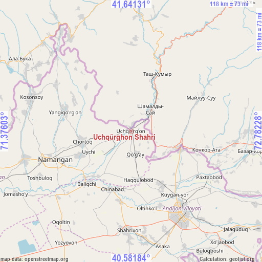
Uchqŭrghon Shahri GPS coordinates[2]
41° 6' 49.356" North, 72° 4' 44.94" East
| Map corner | latitude | longitude |
|---|---|---|
| Upper-left | 41.64131°, | 71.37603° |
| Center: | 41.11371°, | 72.07915° |
| Lower-right: | 40.58184°, | 72.78228° |
| Map W x H: | 117.8×117.8 km | = 73.2×73.2mi |
| max Lat: | 43.77877° ⇑25.9% North |
| Uchqŭrghon Shahri: | 41.11371° |
| min Lat: | ⇓74.1% South 37.22417° |
| min Long | Uchqŭrghon Sha | max Long |
| 58.84596° | 72.07915° | 72.76177° |
| W 92.5%⇐ | ⇒7.5% E |
Elevation
Elevation of Uchqŭrghon Shahri is 496 m = 1627 ft, and this is 62.2 m = 204 ft above average elevation for this country.
| Max E: |
1464 m = 4803 ft | 34.5% |
| Uchqŭrghon Shahri | 496 m 1627 ft | |
| Avg. | 433.8 m = 1423 ft | |
Min E: |
50 m = 164 ft | 65.5% |
See also: Uzbekistan elevation on elevation.city.
Geographical zone
Uchqŭrghon Shahri is located in North temperate zone (between Tropic of Cancer and the Arctic Circle). Distance of this Northern Tropic circle is 1965.5 km =1221.3 mi to South.| Distance of | km | miles | from Uchqŭrghon Shahri |
|---|---|---|---|
| North Pole | 5435.6 | 3377.5 | to North |
| Arctic Circle | 2829.8 | 1758.4 | to North |
| Tropic Cancer | 1965.5 | 1221.3 | to South |
| Equator | 4571.4 | 2840.5 | to South |


Nearby cities:
15 places around Uchqŭrghon Shahri: (largest is in red/bold)
• Andijon
43.1 km =26.8 mi,  148°
148°
• Baliqchi
30.3 km =18.8 mi,  219°
219°
• Chortoq
22 km =13.7 mi,  256°
256°
• Chortoq Shahri
22.3 km =13.9 mi, 259°
• Haqqulobod
22.1 km =13.7 mi,  171°
171°
• Kosonsoy
47 km =29.2 mi,  288°
288°
• Kuyganyor
34.6 km =21.5 mi, 146°
• Namangan
36.4 km =22.6 mi,  249°
249°
• Oltinko‘l
35.6 km =22.1 mi, 167°
• Paxtaobod
40.6 km =25.2 mi,  120°
120°
• Poytug‘
27.8 km =17.3 mi, 149°
• Shahrixon
44.6 km =27.7 mi,  182°
182°
• Toshbuloq
47.4 km =29.5 mi,  242°
242°
• Uychi
13.6 km =8.5 mi, 254°
• Yangiqo‘rg‘on
31.1 km =19.3 mi, 286°
Sources, notices
• [Note1] Compared only with cities in Uzbekistan existing in our database
• [Src1] Map data: © OpenStreetMap contributors (CC-BY-SA)
• [Src2] Other city data from geonames.org with taken over terms of usage.
• [Src3] Geographical zone / Annual Mean Temperature by Robert A. Rohde @ Wikipedia
