Trujillo geodata
Trujillo is a seat of a first-order administrative division; located in Venezuela in America/Caracas (GMT-4) time zone. With population of 38,110 people, there are 89 cities with bigger population in this country. Compared to other cities in Venezuela, 55.5% of cities are located further ↑North; 71.8% of cities are located further →East and 82.2% of cities have lower elevation than Trujillo. Note1


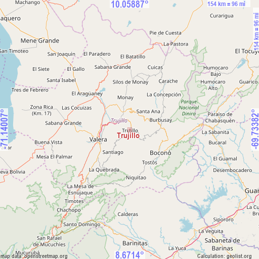
Trujillo GPS coordinates[2]
9° 21' 56.988" North, 70° 26' 12.984" West
| Map corner | latitude | longitude |
|---|---|---|
| Upper-left | 10.05887°, | -71.14007° |
| Center: | 9.36583°, | -70.43694° |
| Lower-right: | 8.6714°, | -69.73382° |
| Map W x H: | 154.3×154.3 km | = 95.9×95.9mi |
| max Lat: | 11.94788° ⇑55.5% North |
| Trujillo: | 9.36583° |
| min Lat: | ⇓44.5% South 1.92027° |
| min Long | Trujillo | max Long |
| -72.55212° | -70.43694° | -60.99778° |
| W 28.2%⇐ | ⇒71.8% E |
Elevation
Elevation of Trujillo is 795 m = 2608 ft, and this is 414.4 m = 1360 ft above average elevation for this country.
| Max E: |
2986 m = 9797 ft | 17.8% |
| Trujillo | 795 m 2608 ft | |
| Avg. | 380.6 m = 1249 ft | |
Min E: |
-4 m = -13 ft | 82.2% |
See also: Venezuela elevation on elevation.city.
Geographical zone
Trujillo is located in North Torrid zone (between Equator and Tropic of Cancer). Distance of Equator is 1041.4 km =647.1 mi to South.| Distance of | km | miles | from Trujillo |
|---|---|---|---|
| North Pole | 8965.7 | 5571 | to North |
| Arctic Circle | 6359.8 | 3951.8 | to North |
| Tropic Cancer | 1564.5 | 972.1 | to North |
| Equator | 1041.4 | 647.1 | to South |


Nearby cities:
15 places around Trujillo: (largest is in red/bold)
• Betijoque
32.5 km =20.2 mi,  273°
273°
• Boconó
23.9 km =14.9 mi,  121°
121°
• Campo Elías
41.6 km =25.8 mi,  85°
85°
• Carache
37.1 km =23.1 mi,  38°
38°
• Carvajal
18.1 km =11.2 mi,  248°
248°
• Chejendé
29.4 km =18.3 mi,  17°
17°
• El Dividive
34.9 km =21.7 mi,  290°
290°
• Escuque
26.9 km =16.7 mi, 253°
• La Quebrada
28 km =17.4 mi,  213°
213°
• Motatán
17.1 km =10.6 mi,  279°
279°
• Pampanito
8.6 km =5.3 mi,  305°
305°
• Pampán
9.8 km =6.1 mi,  334°
334°
• Sabana Grande
39.8 km =24.7 mi, 275°
• Sabana de Mendoza
37.9 km =23.5 mi, 281°
• Valera
19.1 km =11.9 mi, 253°
Sources, notices
• [Note1] Compared only with cities in Venezuela existing in our database
• [Src1] Map data: © OpenStreetMap contributors (CC-BY-SA)
• [Src2] Other city data from geonames.org with taken over terms of usage.
• [Src3] Geographical zone / Annual Mean Temperature by Robert A. Rohde @ Wikipedia
