Lagunillas geodata
Lagunillas (Zulia) is a populated place; located in Venezuela in America/Caracas (GMT-4) time zone. With population of 44,257 people, there are 80 cities with bigger population in this country. Compared to other cities in Venezuela, 62.8% of cities are located further ↓South; 83.5% of cities are located further →East and 100% of cities have higher elevation than Lagunillas. Note1


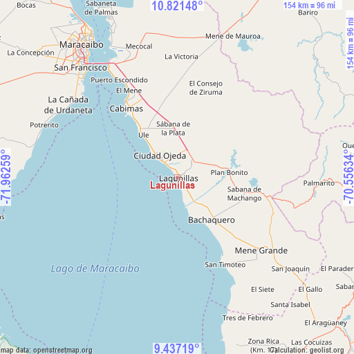
Lagunillas GPS coordinates[2]
10° 7' 48.288" North, 71° 15' 34.056" West
| Map corner | latitude | longitude |
|---|---|---|
| Upper-left | 10.82148°, | -71.96259° |
| Center: | 10.13008°, | -71.25946° |
| Lower-right: | 9.43719°, | -70.55634° |
| Map W x H: | 153.9×153.9 km | = 95.6×95.6mi |
| max Lat: | 11.94788° ⇑37.2% North |
| Lagunillas: | 10.13008° |
| min Lat: | ⇓62.8% South 1.92027° |
| min Long | Lagunillas | max Long |
| -72.55212° | -71.25946° | -60.99778° |
| W 16.5%⇐ | ⇒83.5% E |
Elevation
Elevation of Lagunillas is -4 m = -13 ft, and this is 384.6 m = 1262 ft below average elevation for this country.
| Max E: |
2986 m = 9797 ft | 100% |
| Avg. | 380.6 m = 1249 ft | |
| Lagunillas | -4 m = -13 ft | |
Min E: |
-4 m = -13 ft | 0% |
See also: Lagunillas elevation on elevation.city.
Geographical zone
Lagunillas is located in North Torrid zone (between Equator and Tropic of Cancer). Distance of Equator is 1126.4 km =699.9 mi to South.| Distance of | km | miles | from Lagunillas |
|---|---|---|---|
| North Pole | 8880.7 | 5518.2 | to North |
| Arctic Circle | 6274.8 | 3899 | to North |
| Tropic Cancer | 1479.6 | 919.4 | to North |
| Equator | 1126.4 | 699.9 | to South |


Nearby cities:
15 places around Lagunillas: (largest is in red/bold)
• Bachaquero
23.9 km =14.9 mi,  141°
141°
• Cabimas
36.6 km =22.7 mi,  324°
324°
• Ciudad Ojeda
10 km =6.2 mi, 322°
• Concepción
56.5 km =35.1 mi,  303°
303°
• El Corozo
23.6 km =14.7 mi,  92°
92°
• La Plata
21.2 km =13.2 mi,  356°
356°
• Los Puertos de Altagracia
71.1 km =44.2 mi,  336°
336°
• Maracaibo
71.1 km =44.2 mi,  327°
327°
• Mene de Mauroa
65.9 km =40.9 mi,  21°
21°
• San Francisco
67.7 km =42.1 mi,  314°
314°
• San Timoteo
43.1 km =26.8 mi,  151°
151°
• Santa Apolonia
78.1 km =48.5 mi,  159°
159°
• Santa Isabel
74.3 km =46.2 mi, 138°
• Santa Rita
52.9 km =32.9 mi, 328°
• Tía Juana
18.3 km =11.4 mi, 321°
Sources, notices
• [Note1] Compared only with cities in Venezuela existing in our database
• [Src1] Map data: © OpenStreetMap contributors (CC-BY-SA)
• [Src2] Other city data from geonames.org with taken over terms of usage.
• [Src3] Geographical zone / Annual Mean Temperature by Robert A. Rohde @ Wikipedia
