Monte Carmelo geodata
Monte Carmelo (Trujillo) is a seat of a second-order administrative division; located in Venezuela in America/Caracas (GMT-4) time zone. In our database, there are 108 cities with bigger population. Compared to other cities in Venezuela, 60.1% of cities are located further ↑North; 78.1% of cities are located further →East and 92.4% of cities have lower elevation than Monte Carmelo. Note1


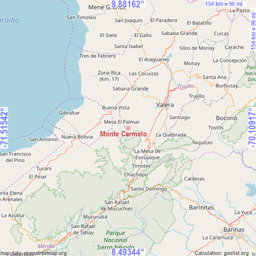
Monte Carmelo GPS coordinates[2]
9° 11' 17.556" North, 70° 48' 44.244" West
| Map corner | latitude | longitude |
|---|---|---|
| Upper-left | 9.88162°, | -71.51542° |
| Center: | 9.18821°, | -70.81229° |
| Lower-right: | 8.49344°, | -70.10917° |
| Map W x H: | 154.4×154.4 km | = 95.9×95.9mi |
| max Lat: | 11.94788° ⇑60.1% North |
| Monte Carmelo: | 9.18821° |
| min Lat: | ⇓39.9% South 1.92027° |
| min Long | Monte Carmelo | max Long |
| -72.55212° | -70.81229° | -60.99778° |
| W 21.9%⇐ | ⇒78.1% E |
Elevation
Elevation of Monte Carmelo is 1161 m = 3809 ft, and this is 780.4 m = 2560 ft above average elevation for this country.
| Max E: |
2986 m = 9797 ft | 7.6% |
| Monte Carmelo | 1161 m 3809 ft | |
| Avg. | 380.6 m = 1249 ft | |
Min E: |
-4 m = -13 ft | 92.4% |
See also: Venezuela elevation on elevation.city.
Geographical zone
Monte Carmelo is located in North Torrid zone (between Equator and Tropic of Cancer). Distance of Equator is 1021.6 km =634.8 mi to South.| Distance of | km | miles | from Monte Carmelo |
|---|---|---|---|
| North Pole | 8985.4 | 5583.3 | to North |
| Arctic Circle | 6379.5 | 3964 | to North |
| Tropic Cancer | 1584.3 | 984.4 | to North |
| Equator | 1021.6 | 634.8 | to South |


Nearby cities:
15 places around Monte Carmelo: (largest is in red/bold)
• Arapuey
17.3 km =10.7 mi,  297°
297°
• Betijoque
23.2 km =14.4 mi,  22°
22°
• Carvajal
27.7 km =17.2 mi,  61°
61°
• El Dividive
33 km =20.5 mi,  14°
14°
• Escuque
19.6 km =12.2 mi,  51°
51°
• La Quebrada
26.1 km =16.2 mi,  98°
98°
• Motatán
33.2 km =20.6 mi, 47°
• Nueva Bolivia
31.1 km =19.3 mi,  260°
260°
• Pueblo Llano
34.7 km =21.6 mi,  151°
151°
• Sabana Grande
23.8 km =14.8 mi,  3°
3°
• Sabana de Mendoza
27.7 km =17.2 mi, 8°
• Santa Apolonia
38.4 km =23.9 mi,  325°
325°
• Timotes
24.3 km =15.1 mi,  160°
160°
• Torondoy
28 km =17.4 mi,  232°
232°
• Valera
27.1 km =16.8 mi, 57°
Sources, notices
• [Note1] Compared only with cities in Venezuela existing in our database
• [Src1] Map data: © OpenStreetMap contributors (CC-BY-SA)
• [Src2] Other city data from geonames.org with taken over terms of usage.
• [Src3] Geographical zone / Annual Mean Temperature by Robert A. Rohde @ Wikipedia
