Pueblo Llano geodata
Pueblo Llano (Mérida) is a seat of a second-order administrative division; located in Venezuela in America/Caracas (GMT-4) time zone. In our database, there are 108 cities with bigger population. Compared to other cities in Venezuela, 65.4% of cities are located further ↑North; 75.1% of cities are located further →East and 99.5% of cities have lower elevation than Pueblo Llano. Note1


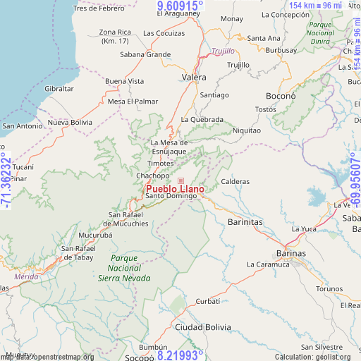
Pueblo Llano GPS coordinates[2]
8° 54' 54.72" North, 70° 39' 33.084" West
| Map corner | latitude | longitude |
|---|---|---|
| Upper-left | 9.60915°, | -71.36232° |
| Center: | 8.9152°, | -70.65919° |
| Lower-right: | 8.21993°, | -69.95607° |
| Map W x H: | 154.5×154.5 km | = 96×96mi |
| max Lat: | 11.94788° ⇑65.4% North |
| Pueblo Llano: | 8.9152° |
| min Lat: | ⇓34.6% South 1.92027° |
| min Long | Pueblo Llano | max Long |
| -72.55212° | -70.65919° | -60.99778° |
| W 24.9%⇐ | ⇒75.1% E |
Elevation
Elevation of Pueblo Llano is 2161 m = 7090 ft, and this is 1780.4 m = 5841 ft above average elevation for this country.
| Max E: |
2986 m = 9797 ft | 0.5% |
| Pueblo Llano | 2161 m 7090 ft | |
| Avg. | 380.6 m = 1249 ft | |
Min E: |
-4 m = -13 ft | 99.5% |
See also: Venezuela elevation on elevation.city.
Geographical zone
Pueblo Llano is located in North Torrid zone (between Equator and Tropic of Cancer). Distance of Equator is 991.3 km =616 mi to South.| Distance of | km | miles | from Pueblo Llano |
|---|---|---|---|
| North Pole | 9015.8 | 5602.2 | to North |
| Arctic Circle | 6409.9 | 3982.9 | to North |
| Tropic Cancer | 1614.6 | 1003.3 | to North |
| Equator | 991.3 | 616 | to South |


Nearby cities:
15 places around Pueblo Llano: (largest is in red/bold)
• Altamira
20 km =12.4 mi,  120°
120°
• Barinitas
32.1 km =19.9 mi, 122°
• Calderas
23.3 km =14.5 mi,  90°
90°
• Carvajal
44.2 km =27.5 mi,  9°
9°
• Escuque
42.5 km =26.4 mi,  358°
358°
• La Mula
49.4 km =30.7 mi,  140°
140°
• La Quebrada
28.2 km =17.5 mi,  18°
18°
• Masparrito
40.5 km =25.2 mi,  76°
76°
• Monte Carmelo
34.7 km =21.6 mi,  331°
331°
• Mucuchíes
34.1 km =21.2 mi,  237°
237°
• Quebrada Seca
44.3 km =27.5 mi, 122°
• Santo Domingo
7.2 km =4.5 mi,  212°
212°
• Timotes
11.5 km =7.1 mi,  310°
310°
• Torondoy
41.2 km =25.6 mi,  288°
288°
• Valera
45.2 km =28.1 mi, 7°
Sources, notices
• [Note1] Compared only with cities in Venezuela existing in our database
• [Src1] Map data: © OpenStreetMap contributors (CC-BY-SA)
• [Src2] Other city data from geonames.org with taken over terms of usage.
• [Src3] Geographical zone / Annual Mean Temperature by Robert A. Rohde @ Wikipedia
