Timotes geodata
Timotes (Mérida) is a seat of a second-order administrative division; located in Venezuela in America/Caracas (GMT-4) time zone. In our database, there are 108 cities with bigger population. Compared to other cities in Venezuela, 63.9% of cities are located further ↑North; 76.8% of cities are located further →East and 98.7% of cities have lower elevation than Timotes. Note1


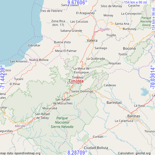
Timotes GPS coordinates[2]
8° 58' 56.064" North, 70° 44' 21.336" West
| Map corner | latitude | longitude |
|---|---|---|
| Upper-left | 9.67606°, | -71.44239° |
| Center: | 8.98224°, | -70.73926° |
| Lower-right: | 8.28709°, | -70.03614° |
| Map W x H: | 154.4×154.4 km | = 95.9×95.9mi |
| max Lat: | 11.94788° ⇑63.9% North |
| Timotes: | 8.98224° |
| min Lat: | ⇓36.1% South 1.92027° |
| min Long | Timotes | max Long |
| -72.55212° | -70.73926° | -60.99778° |
| W 23.2%⇐ | ⇒76.8% E |
Elevation
Elevation of Timotes is 2001 m = 6565 ft, and this is 1620.4 m = 5316 ft above average elevation for this country.
| Max E: |
2986 m = 9797 ft | 1.3% |
| Timotes | 2001 m 6565 ft | |
| Avg. | 380.6 m = 1249 ft | |
Min E: |
-4 m = -13 ft | 98.7% |
See also: Venezuela elevation on elevation.city.
Geographical zone
Timotes is located in North Torrid zone (between Equator and Tropic of Cancer). Distance of Equator is 998.7 km =620.6 mi to South.| Distance of | km | miles | from Timotes |
|---|---|---|---|
| North Pole | 9008.3 | 5597.5 | to North |
| Arctic Circle | 6402.4 | 3978.3 | to North |
| Tropic Cancer | 1607.2 | 998.7 | to North |
| Equator | 998.7 | 620.6 | to South |


Nearby cities:
15 places around Timotes: (largest is in red/bold)
• Altamira
31.4 km =19.5 mi,  124°
124°
• Arapuey
38.7 km =24 mi,  322°
322°
• Barinitas
43.5 km =27 mi, 124°
• Betijoque
44.4 km =27.6 mi,  0°
0°
• Calderas
32.9 km =20.4 mi,  103°
103°
• Carvajal
39.6 km =24.6 mi,  24°
24°
• Escuque
35.8 km =22.2 mi,  11°
11°
• La Quebrada
26.2 km =16.3 mi,  42°
42°
• Monte Carmelo
24.3 km =15.1 mi,  340°
340°
• Mucuchíes
32.6 km =20.3 mi,  217°
217°
• Nueva Bolivia
42.5 km =26.4 mi,  294°
294°
• Pueblo Llano
11.5 km =7.1 mi,  130°
130°
• Santo Domingo
14.4 km =8.9 mi,  160°
160°
• Torondoy
30.7 km =19.1 mi,  280°
280°
• Valera
40.2 km =25 mi, 21°
Sources, notices
• [Note1] Compared only with cities in Venezuela existing in our database
• [Src1] Map data: © OpenStreetMap contributors (CC-BY-SA)
• [Src2] Other city data from geonames.org with taken over terms of usage.
• [Src3] Geographical zone / Annual Mean Temperature by Robert A. Rohde @ Wikipedia
