La Yuca geodata
La Yuca (Barinas) is a seat of a third-order administrative division; located in Venezuela in America/Caracas (GMT-4) time zone. In our database, there are 108 cities with bigger population. Compared to other cities in Venezuela, 69.5% of cities are located further ↑North; 67.2% of cities are located further →East and 57.8% of cities have lower elevation than La Yuca. Note1
Administrative division(s):
- Level 1: Barinas
- Level 2: Municipio Cruz Paredes
- Level 3: Parroquia El Socorro


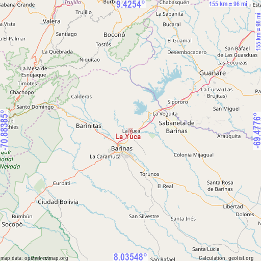
La Yuca GPS coordinates[2]
8° 43' 51.924" North, 70° 10' 50.592" West
| Map corner | latitude | longitude |
|---|---|---|
| Upper-left | 9.4254°, | -70.88385° |
| Center: | 8.73109°, | -70.18072° |
| Lower-right: | 8.03548°, | -69.4776° |
| Map W x H: | 154.5×154.5 km | = 96×96mi |
| max Lat: | 11.94788° ⇑69.5% North |
| La Yuca: | 8.73109° |
| min Lat: | ⇓30.5% South 1.92027° |
| min Long | La Yuca | max Long |
| -72.55212° | -70.18072° | -60.99778° |
| W 32.8%⇐ | ⇒67.2% E |
Elevation
Elevation of La Yuca is 224 m = 735 ft, and this is 156.6 m = 514 ft below average elevation for this country.
| Max E: |
2986 m = 9797 ft | 42.2% |
| Avg. | 380.6 m = 1249 ft | |
| La Yuca | 224 m = 735 ft | |
Min E: |
-4 m = -13 ft | 57.8% |
See also: Venezuela elevation on elevation.city.
Geographical zone
La Yuca is located in North Torrid zone (between Equator and Tropic of Cancer). Distance of Equator is 970.8 km =603.2 mi to South.| Distance of | km | miles | from La Yuca |
|---|---|---|---|
| North Pole | 9036.3 | 5614.9 | to North |
| Arctic Circle | 6430.4 | 3995.7 | to North |
| Tropic Cancer | 1635.1 | 1016 | to North |
| Equator | 970.8 | 603.2 | to South |


Nearby cities:
15 places around La Yuca: (largest is in red/bold)
• Alto Barinas
16.1 km =10 mi,  198°
198°
• Barinas
12.4 km =7.7 mi,  193°
193°
• Barinitas
25.6 km =15.9 mi,  277°
277°
• Barrancas
8.8 km =5.5 mi,  60°
60°
• Boconoito
25.5 km =15.8 mi, 59°
• Caramuca
21.4 km =13.3 mi,  225°
225°
• El Corozo
26.6 km =16.5 mi, 226°
• La Mula
27.8 km =17.3 mi, 230°
• Los Guasimitos
9.3 km =5.8 mi,  217°
217°
• Masparrito
32.9 km =20.4 mi,  336°
336°
• Obispos
16.1 km =10 mi,  148°
148°
• Quebrada Seca
15.6 km =9.7 mi,  257°
257°
• Sabaneta
27.3 km =17 mi,  85°
85°
• Torunos
27.9 km =17.3 mi,  156°
156°
• Veguitas
22.8 km =14.2 mi, 63°
Sources, notices
• [Note1] Compared only with cities in Venezuela existing in our database
• [Src1] Map data: © OpenStreetMap contributors (CC-BY-SA)
• [Src2] Other city data from geonames.org with taken over terms of usage.
• [Src3] Geographical zone / Annual Mean Temperature by Robert A. Rohde @ Wikipedia
