Barinas geodata
Barinas is a seat of a first-order administrative division; located in Venezuela in America/Caracas (GMT-4) time zone. With population of 353,442 people, there are 10 cities with bigger population in this country. Compared to other cities in Venezuela, 71.5% of cities are located further ↑North; 67.7% of cities are located further →East and 51.4% of cities have lower elevation than Barinas. Note1


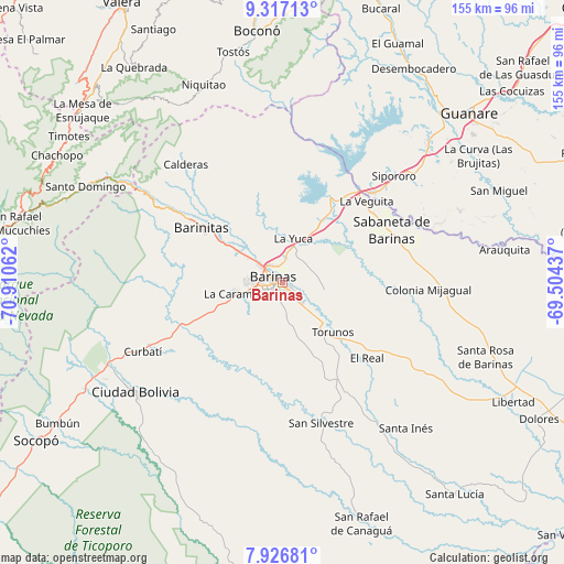
Barinas GPS coordinates[2]
8° 37' 21.396" North, 70° 12' 26.964" West
| Map corner | latitude | longitude |
|---|---|---|
| Upper-left | 9.31713°, | -70.91062° |
| Center: | 8.62261°, | -70.20749° |
| Lower-right: | 7.92681°, | -69.50437° |
| Map W x H: | 154.6×154.6 km | = 96.1×96.1mi |
| max Lat: | 11.94788° ⇑71.5% North |
| Barinas: | 8.62261° |
| min Lat: | ⇓28.5% South 1.92027° |
| min Long | Barinas | max Long |
| -72.55212° | -70.20749° | -60.99778° |
| W 32.3%⇐ | ⇒67.7% E |
Elevation
Elevation of Barinas is 187 m = 614 ft, and this is 193.6 m = 635 ft below average elevation for this country.
| Max E: |
2986 m = 9797 ft | 48.6% |
| Avg. | 380.6 m = 1249 ft | |
| Barinas | 187 m = 614 ft | |
Min E: |
-4 m = -13 ft | 51.4% |
See also: Barinas elevation on elevation.city.
Geographical zone
Barinas is located in North Torrid zone (between Equator and Tropic of Cancer). Distance of Equator is 958.7 km =595.7 mi to South.| Distance of | km | miles | from Barinas |
|---|---|---|---|
| North Pole | 9048.3 | 5622.4 | to North |
| Arctic Circle | 6442.4 | 4003.1 | to North |
| Tropic Cancer | 1647.2 | 1023.5 | to North |
| Equator | 958.7 | 595.7 | to South |


Nearby cities:
15 places around Barinas: (largest is in red/bold)
• Alto Barinas
3.9 km =2.4 mi,  211°
211°
• Barinitas
27.3 km =17 mi,  304°
304°
• Barrancas
19.5 km =12.1 mi,  33°
33°
• Boconoito
35.3 km =21.9 mi,  45°
45°
• Caramuca
12.8 km =8 mi,  257°
257°
• El Corozo
17.6 km =10.9 mi,  249°
249°
• El Real
31.2 km =19.4 mi,  131°
131°
• La Mula
19.3 km =12 mi, 252°
• La Yuca
12.4 km =7.7 mi,  13°
13°
• Los Guasimitos
5.4 km =3.4 mi,  329°
329°
• Obispos
11.4 km =7.1 mi,  98°
98°
• Quebrada Seca
15 km =9.3 mi,  305°
305°
• Sabaneta
33.4 km =20.8 mi,  64°
64°
• Torunos
19.5 km =12.1 mi, 134°
• Veguitas
32.3 km =20.1 mi, 46°
Sources, notices
• [Note1] Compared only with cities in Venezuela existing in our database
• [Src1] Map data: © OpenStreetMap contributors (CC-BY-SA)
• [Src2] Other city data from geonames.org with taken over terms of usage.
• [Src3] Geographical zone / Annual Mean Temperature by Robert A. Rohde @ Wikipedia
