Torunos geodata
Torunos (Barinas) is a seat of a third-order administrative division; located in Venezuela in America/Caracas (GMT-4) time zone. In our database, there are 108 cities with bigger population. Compared to other cities in Venezuela, 74.8% of cities are located further ↑North; 65.6% of cities are located further →East and 59% of cities have higher elevation than Torunos. Note1


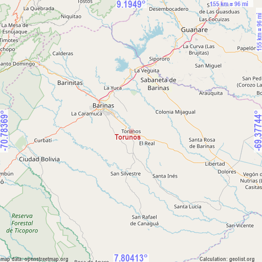
Torunos GPS coordinates[2]
8° 30' 0.54" North, 70° 4' 50.016" West
| Map corner | latitude | longitude |
|---|---|---|
| Upper-left | 9.1949°, | -70.78369° |
| Center: | 8.50015°, | -70.08056° |
| Lower-right: | 7.80413°, | -69.37744° |
| Map W x H: | 154.6×154.6 km | = 96.1×96.1mi |
| max Lat: | 11.94788° ⇑74.8% North |
| Torunos: | 8.50015° |
| min Lat: | ⇓25.2% South 1.92027° |
| min Long | Torunos | max Long |
| -72.55212° | -70.08056° | -60.99778° |
| W 34.4%⇐ | ⇒65.6% E |
Elevation
Elevation of Torunos is 142 m = 466 ft, and this is 238.6 m = 783 ft below average elevation for this country.
| Max E: |
2986 m = 9797 ft | 59% |
| Avg. | 380.6 m = 1249 ft | |
| Torunos | 142 m = 466 ft | |
Min E: |
-4 m = -13 ft | 41% |
See also: Venezuela elevation on elevation.city.
Geographical zone
Torunos is located in North Torrid zone (between Equator and Tropic of Cancer). Distance of Equator is 945.1 km =587.3 mi to South.| Distance of | km | miles | from Torunos |
|---|---|---|---|
| North Pole | 9061.9 | 5630.8 | to North |
| Arctic Circle | 6456 | 4011.6 | to North |
| Tropic Cancer | 1660.8 | 1032 | to North |
| Equator | 945.1 | 587.3 | to South |


Nearby cities:
15 places around Torunos: (largest is in red/bold)
• Alto Barinas
19.1 km =11.9 mi,  302°
302°
• Barinas
19.5 km =12.1 mi,  314°
314°
• Barrancas
30.1 km =18.7 mi,  353°
353°
• Caramuca
28.5 km =17.7 mi,  292°
292°
• El Corozo
31.4 km =19.5 mi,  283°
283°
• El Real
11.7 km =7.3 mi,  127°
127°
• La Luz
30.6 km =19 mi,  112°
112°
• La Mula
33.3 km =20.7 mi, 283°
• La Yuca
27.9 km =17.3 mi,  336°
336°
• Los Guasimitos
24.7 km =15.3 mi,  317°
317°
• Obispos
12.2 km =7.6 mi, 347°
• Quebrada Seca
34.4 km =21.4 mi, 310°
• Sabaneta
32.4 km =20.1 mi,  29°
29°
• San Silvestre
25.2 km =15.7 mi,  187°
187°
• Santa Inés
33.2 km =20.6 mi,  142°
142°
Sources, notices
• [Note1] Compared only with cities in Venezuela existing in our database
• [Src1] Map data: © OpenStreetMap contributors (CC-BY-SA)
• [Src2] Other city data from geonames.org with taken over terms of usage.
• [Src3] Geographical zone / Annual Mean Temperature by Robert A. Rohde @ Wikipedia
