La Mula geodata
La Mula (Barinas) is a seat of a third-order administrative division; located in Venezuela in America/Caracas (GMT-4) time zone. In our database, there are 108 cities with bigger population. Compared to other cities in Venezuela, 73.3% of cities are located further ↑North; 71% of cities are located further →East and 57.3% of cities have lower elevation than La Mula. Note1
Administrative division(s):
- Level 1: Barinas
- Level 2: Municipio Barinas
- Level 3: Parroquia Dominga Ortiz de Páez


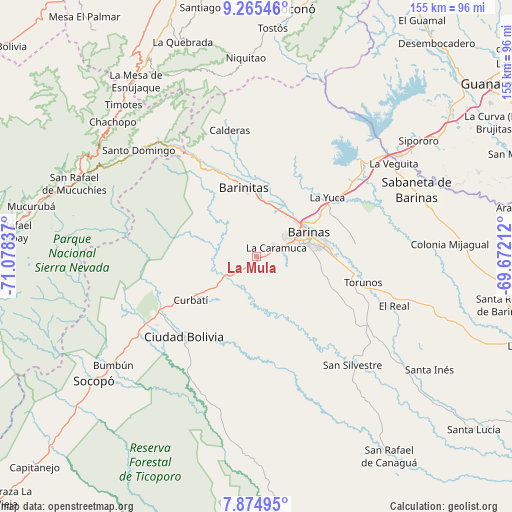
La Mula GPS coordinates[2]
8° 34' 15.024" North, 70° 22' 30.864" West
| Map corner | latitude | longitude |
|---|---|---|
| Upper-left | 9.26546°, | -71.07837° |
| Center: | 8.57084°, | -70.37524° |
| Lower-right: | 7.87495°, | -69.67212° |
| Map W x H: | 154.6×154.6 km | = 96.1×96.1mi |
| max Lat: | 11.94788° ⇑73.3% North |
| La Mula: | 8.57084° |
| min Lat: | ⇓26.7% South 1.92027° |
| min Long | La Mula | max Long |
| -72.55212° | -70.37524° | -60.99778° |
| W 29%⇐ | ⇒71% E |
Elevation
Elevation of La Mula is 222 m = 728 ft, and this is 158.6 m = 520 ft below average elevation for this country.
| Max E: |
2986 m = 9797 ft | 42.7% |
| Avg. | 380.6 m = 1249 ft | |
| La Mula | 222 m = 728 ft | |
Min E: |
-4 m = -13 ft | 57.3% |
See also: Venezuela elevation on elevation.city.
Geographical zone
La Mula is located in North Torrid zone (between Equator and Tropic of Cancer). Distance of Equator is 953 km =592.2 mi to South.| Distance of | km | miles | from La Mula |
|---|---|---|---|
| North Pole | 9054.1 | 5626 | to North |
| Arctic Circle | 6448.2 | 4006.7 | to North |
| Tropic Cancer | 1652.9 | 1027.1 | to North |
| Equator | 953 | 592.2 | to South |


Nearby cities:
15 places around La Mula: (largest is in red/bold)
• Altamira
31.4 km =19.5 mi,  333°
333°
• Alto Barinas
16.6 km =10.3 mi,  81°
81°
• Barinas
19.3 km =12 mi,  72°
72°
• Barinitas
21.6 km =13.4 mi,  349°
349°
• Barrancas
36.5 km =22.7 mi,  52°
52°
• Calderas
39 km =24.2 mi, 348°
• Caramuca
6.7 km =4.2 mi,  64°
64°
• Ciudad Bolivia
32.4 km =20.1 mi,  221°
221°
• Curbatí
23.6 km =14.7 mi,  236°
236°
• El Corozo
2 km =1.2 mi,  100°
100°
• La Yuca
27.8 km =17.3 mi, 50°
• Los Guasimitos
18.9 km =11.7 mi, 56°
• Obispos
30 km =18.6 mi, 82°
• Quebrada Seca
15.6 km =9.7 mi,  23°
23°
• Torunos
33.3 km =20.7 mi, 103°
Sources, notices
• [Note1] Compared only with cities in Venezuela existing in our database
• [Src1] Map data: © OpenStreetMap contributors (CC-BY-SA)
• [Src2] Other city data from geonames.org with taken over terms of usage.
• [Src3] Geographical zone / Annual Mean Temperature by Robert A. Rohde @ Wikipedia
