El Consejo geodata
El Consejo (Aragua) is a seat of a second-order administrative division; located in Venezuela in America/Caracas (GMT-4) time zone. In our database, there are 108 cities with bigger population. Compared to other cities in Venezuela, 70.5% of cities are located further ↓South; 66.7% of cities are located further ←West and 78.1% of cities have lower elevation than El Consejo. Note1


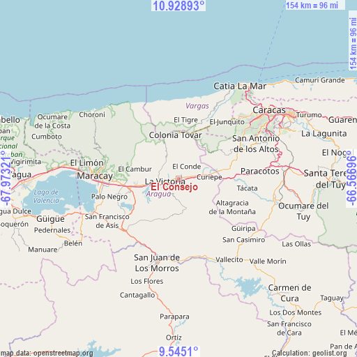
El Consejo GPS coordinates[2]
10° 14' 15.972" North, 67° 16' 12.288" West
| Map corner | latitude | longitude |
|---|---|---|
| Upper-left | 10.92893°, | -67.97321° |
| Center: | 10.23777°, | -67.27008° |
| Lower-right: | 9.5451°, | -66.56696° |
| Map W x H: | 153.9×153.9 km | = 95.6×95.6mi |
| max Lat: | 11.94788° ⇑29.5% North |
| El Consejo: | 10.23777° |
| min Lat: | ⇓70.5% South 1.92027° |
| min Long | El Consejo | max Long |
| -72.55212° | -67.27008° | -60.99778° |
| W 66.7%⇐ | ⇒33.3% E |
Elevation
Elevation of El Consejo is 589 m = 1932 ft, and this is 208.4 m = 684 ft above average elevation for this country.
| Max E: |
2986 m = 9797 ft | 21.9% |
| El Consejo | 589 m 1932 ft | |
| Avg. | 380.6 m = 1249 ft | |
Min E: |
-4 m = -13 ft | 78.1% |
See also: Venezuela elevation on elevation.city.
Geographical zone
El Consejo is located in North Torrid zone (between Equator and Tropic of Cancer). Distance of Equator is 1138.3 km =707.3 mi to South.| Distance of | km | miles | from El Consejo |
|---|---|---|---|
| North Pole | 8868.7 | 5510.8 | to North |
| Arctic Circle | 6262.8 | 3891.5 | to North |
| Tropic Cancer | 1467.6 | 911.9 | to North |
| Equator | 1138.3 | 707.3 | to South |


Nearby cities:
15 places around El Consejo: (largest is in red/bold)
• Cagua
21.5 km =13.4 mi,  254°
254°
• Carrizal
33.5 km =20.8 mi,  68°
68°
• El Junko
33.1 km =20.6 mi,  38°
38°
• La Victoria
6.8 km =4.2 mi,  259°
259°
• Las Tejerías
10.7 km =6.6 mi,  80°
80°
• Los Teques
27.5 km =17.1 mi,  64°
64°
• Maracay
35.1 km =21.8 mi,  269°
269°
• Palo Negro
30.6 km =19 mi, 256°
• San Juan de los Morros
37.4 km =23.2 mi,  194°
194°
• San Mateo
17 km =10.6 mi, 260°
• San Sebastián
34.7 km =21.6 mi,  161°
161°
• Santa Cruz
27.2 km =16.9 mi, 256°
• Santa Rita
31.9 km =19.8 mi, 263°
• Turmero
22.4 km =13.9 mi, 267°
• Villa de Cura
32.7 km =20.3 mi,  227°
227°
Sources, notices
• [Note1] Compared only with cities in Venezuela existing in our database
• [Src1] Map data: © OpenStreetMap contributors (CC-BY-SA)
• [Src2] Other city data from geonames.org with taken over terms of usage.
• [Src3] Geographical zone / Annual Mean Temperature by Robert A. Rohde @ Wikipedia
