Los Teques geodata
Los Teques (Miranda) is a seat of a first-order administrative division; located in Venezuela in America/Caracas (GMT-4) time zone. With population of 140,617 people, there are 31 cities with bigger population in this country. Compared to other cities in Venezuela, 76.3% of cities are located further ↓South; 68.2% of cities are located further ←West and 92.6% of cities have lower elevation than Los Teques. Note1


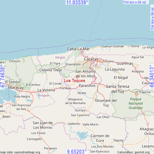
Los Teques GPS coordinates[2]
10° 20' 40.092" North, 67° 2' 35.7" West
| Map corner | latitude | longitude |
|---|---|---|
| Upper-left | 11.03539°, | -67.74638° |
| Center: | 10.34447°, | -67.04325° |
| Lower-right: | 9.65203°, | -66.34013° |
| Map W x H: | 153.8×153.8 km | = 95.6×95.6mi |
| max Lat: | 11.94788° ⇑23.7% North |
| Los Teques: | 10.34447° |
| min Lat: | ⇓76.3% South 1.92027° |
| min Long | Los Teques | max Long |
| -72.55212° | -67.04325° | -60.99778° |
| W 68.2%⇐ | ⇒31.8% E |
Elevation
Elevation of Los Teques is 1185 m = 3888 ft, and this is 804.4 m = 2639 ft above average elevation for this country.
| Max E: |
2986 m = 9797 ft | 7.4% |
| Los Teques | 1185 m 3888 ft | |
| Avg. | 380.6 m = 1249 ft | |
Min E: |
-4 m = -13 ft | 92.6% |
See also: Los Teques elevation on elevation.city.
Geographical zone
Los Teques is located in North Torrid zone (between Equator and Tropic of Cancer). Distance of Equator is 1150.2 km =714.7 mi to South.| Distance of | km | miles | from Los Teques |
|---|---|---|---|
| North Pole | 8856.9 | 5503.4 | to North |
| Arctic Circle | 6251 | 3884.2 | to North |
| Tropic Cancer | 1455.7 | 904.5 | to North |
| Equator | 1150.2 | 714.7 | to South |


Nearby cities:
15 places around Los Teques: (largest is in red/bold)
• Baruta
20.9 km =13 mi,  61°
61°
• Caracas
24 km =14.9 mi,  48°
48°
• Caricuao
11.9 km =7.4 mi,  33°
33°
• Carrizal
6.3 km =3.9 mi,  84°
84°
• Caucaguita
26.4 km =16.4 mi,  86°
86°
• Chacao
26.7 km =16.6 mi, 50°
• Charallave
23.3 km =14.5 mi,  119°
119°
• Cúa
26.8 km =16.7 mi,  139°
139°
• El Cafetal
27 km =16.8 mi, 60°
• El Consejo
27.5 km =17.1 mi,  244°
244°
• El Hatillo
25.4 km =15.8 mi,  69°
69°
• El Junko
14.9 km =9.3 mi,  342°
342°
• Las Tejerías
17.4 km =10.8 mi,  234°
234°
• Los Dos Caminos
28.8 km =17.9 mi, 54°
• San Antonio de Los Altos
11.1 km =6.9 mi, 63°
Sources, notices
• [Note1] Compared only with cities in Venezuela existing in our database
• [Src1] Map data: © OpenStreetMap contributors (CC-BY-SA)
• [Src2] Other city data from geonames.org with taken over terms of usage.
• [Src3] Geographical zone / Annual Mean Temperature by Robert A. Rohde @ Wikipedia
