Bobures geodata
Bobures (Zulia) is a seat of a second-order administrative division; located in Venezuela in America/Caracas (GMT-4) time zone. In our database, there are 108 cities with bigger population. Compared to other cities in Venezuela, 59.3% of cities are located further ↑North; 82.7% of cities are located further →East and 96.4% of cities have higher elevation than Bobures. Note1


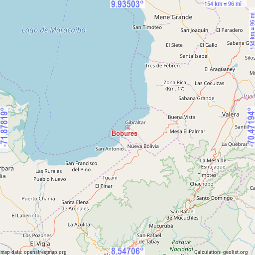
Bobures GPS coordinates[2]
9° 14' 30.228" North, 71° 10' 30.216" West
| Map corner | latitude | longitude |
|---|---|---|
| Upper-left | 9.93503°, | -71.87819° |
| Center: | 9.24173°, | -71.17506° |
| Lower-right: | 8.54706°, | -70.47194° |
| Map W x H: | 154.3×154.3 km | = 95.9×95.9mi |
| max Lat: | 11.94788° ⇑59.3% North |
| Bobures: | 9.24173° |
| min Lat: | ⇓40.7% South 1.92027° |
| min Long | Bobures | max Long |
| -72.55212° | -71.17506° | -60.99778° |
| W 17.3%⇐ | ⇒82.7% E |
Elevation
Elevation of Bobures is 3 m = 10 ft, and this is 377.6 m = 1239 ft below average elevation for this country.
| Max E: |
2986 m = 9797 ft | 96.4% |
| Avg. | 380.6 m = 1249 ft | |
| Bobures | 3 m = 10 ft | |
Min E: |
-4 m = -13 ft | 3.6% |
See also: Venezuela elevation on elevation.city.
Geographical zone
Bobures is located in North Torrid zone (between Equator and Tropic of Cancer). Distance of Equator is 1027.6 km =638.5 mi to South.| Distance of | km | miles | from Bobures |
|---|---|---|---|
| North Pole | 8979.5 | 5579.6 | to North |
| Arctic Circle | 6373.6 | 3960.4 | to North |
| Tropic Cancer | 1578.3 | 980.7 | to North |
| Equator | 1027.6 | 638.5 | to South |


Nearby cities:
15 places around Bobures: (largest is in red/bold)
• Arapuey
24.5 km =15.2 mi,  85°
85°
• Betijoque
50.9 km =31.6 mi,  72°
72°
• El Dividive
54.8 km =34.1 mi,  61°
61°
• Escuque
55.6 km =34.5 mi,  83°
83°
• Monte Carmelo
40.3 km =25 mi,  98°
98°
• Nueva Bolivia
14.6 km =9.1 mi,  140°
140°
• Pueblo Nuevo El Chivo
56.7 km =35.2 mi,  236°
236°
• Sabana Grande
45 km =28 mi, 66°
• Sabana de Mendoza
48.9 km =30.4 mi, 63°
• Santa Apolonia
31.2 km =19.4 mi,  34°
34°
• Santa Elena de Arenales
56.7 km =35.2 mi,  214°
214°
• Santa Isabel
59.1 km =36.7 mi,  42°
42°
• Timotes
55.9 km =34.7 mi,  121°
121°
• Torondoy
29 km =18 mi, 142°
• Tucaní
32.1 km =19.9 mi,  199°
199°
Sources, notices
• [Note1] Compared only with cities in Venezuela existing in our database
• [Src1] Map data: © OpenStreetMap contributors (CC-BY-SA)
• [Src2] Other city data from geonames.org with taken over terms of usage.
• [Src3] Geographical zone / Annual Mean Temperature by Robert A. Rohde @ Wikipedia
