Tucaní geodata
Tucaní (Mérida) is a seat of a second-order administrative division; located in Venezuela in America/Caracas (GMT-4) time zone. In our database, there are 108 cities with bigger population. Compared to other cities in Venezuela, 64.1% of cities are located further ↑North; 84% of cities are located further →East and 52.7% of cities have higher elevation than Tucaní. Note1


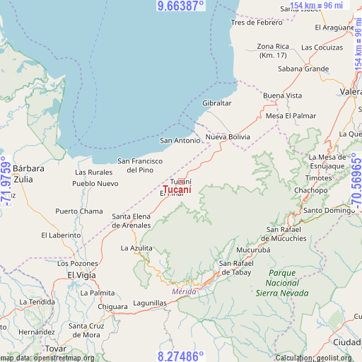
Tucaní GPS coordinates[2]
8° 58' 12.108" North, 71° 16' 21.972" West
| Map corner | latitude | longitude |
|---|---|---|
| Upper-left | 9.66387°, | -71.9759° |
| Center: | 8.97003°, | -71.27277° |
| Lower-right: | 8.27486°, | -70.56965° |
| Map W x H: | 154.4×154.4 km | = 95.9×95.9mi |
| max Lat: | 11.94788° ⇑64.1% North |
| Tucaní: | 8.97003° |
| min Lat: | ⇓35.9% South 1.92027° |
| min Long | Tucaní | max Long |
| -72.55212° | -71.27277° | -60.99778° |
| W 16%⇐ | ⇒84% E |
Elevation
Elevation of Tucaní is 169 m = 554 ft, and this is 211.6 m = 694 ft below average elevation for this country.
| Max E: |
2986 m = 9797 ft | 52.7% |
| Avg. | 380.6 m = 1249 ft | |
| Tucaní | 169 m = 554 ft | |
Min E: |
-4 m = -13 ft | 47.3% |
See also: Venezuela elevation on elevation.city.
Geographical zone
Tucaní is located in North Torrid zone (between Equator and Tropic of Cancer). Distance of Equator is 997.4 km =619.8 mi to South.| Distance of | km | miles | from Tucaní |
|---|---|---|---|
| North Pole | 9009.7 | 5598.4 | to North |
| Arctic Circle | 6403.8 | 3979.1 | to North |
| Tropic Cancer | 1608.5 | 999.5 | to North |
| Equator | 997.4 | 619.8 | to South |


Nearby cities:
15 places around Tucaní: (largest is in red/bold)
• Arapuey
47.7 km =29.6 mi,  47°
47°
• Bobures
32.1 km =19.9 mi,  19°
19°
• Ejido
47.2 km =29.3 mi,  175°
175°
• El Vigía
57.9 km =36 mi,  226°
226°
• La Azulita
34.2 km =21.3 mi,  213°
213°
• Lagunillas
53.3 km =33.1 mi,  193°
193°
• Monte Carmelo
56.1 km =34.9 mi,  64°
64°
• Mucuchíes
45.9 km =28.5 mi,  122°
122°
• Mérida
44.2 km =27.5 mi,  163°
163°
• Nueva Bolivia
27.5 km =17.1 mi, 46°
• Pueblo Nuevo El Chivo
36.8 km =22.9 mi,  268°
268°
• Santa Elena de Arenales
26.9 km =16.7 mi, 231°
• Tabay
43.3 km =26.9 mi,  150°
150°
• Timotes
58.6 km =36.4 mi,  88°
88°
• Torondoy
29.3 km =18.2 mi,  75°
75°
Sources, notices
• [Note1] Compared only with cities in Venezuela existing in our database
• [Src1] Map data: © OpenStreetMap contributors (CC-BY-SA)
• [Src2] Other city data from geonames.org with taken over terms of usage.
• [Src3] Geographical zone / Annual Mean Temperature by Robert A. Rohde @ Wikipedia
