Guasdualito geodata
Guasdualito (Apure) is a seat of a second-order administrative division; located in Venezuela in America/Caracas (GMT-4) time zone. With population of 30,860 people, there are 98 cities with bigger population in this country. Compared to other cities in Venezuela, 97.7% of cities are located further ↑North; 76.1% of cities are located further →East and 60.8% of cities have higher elevation than Guasdualito. Note1


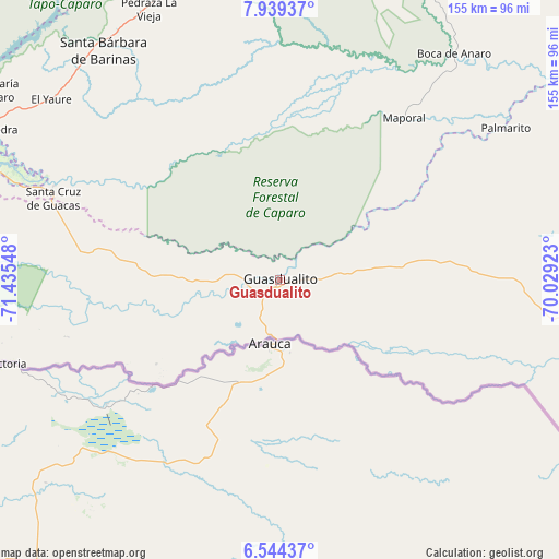
Guasdualito GPS coordinates[2]
7° 14' 32.676" North, 70° 43' 56.46" West
| Map corner | latitude | longitude |
|---|---|---|
| Upper-left | 7.93937°, | -71.43548° |
| Center: | 7.24241°, | -70.73235° |
| Lower-right: | 6.54437°, | -70.02923° |
| Map W x H: | 155.1×155.1 km | = 96.4×96.4mi |
| max Lat: | 11.94788° ⇑97.7% North |
| Guasdualito: | 7.24241° |
| min Lat: | ⇓2.3% South 1.92027° |
| min Long | Guasdualito | max Long |
| -72.55212° | -70.73235° | -60.99778° |
| W 23.9%⇐ | ⇒76.1% E |
Elevation
Elevation of Guasdualito is 130 m = 427 ft, and this is 250.6 m = 822 ft below average elevation for this country.
| Max E: |
2986 m = 9797 ft | 60.8% |
| Avg. | 380.6 m = 1249 ft | |
| Guasdualito | 130 m = 427 ft | |
Min E: |
-4 m = -13 ft | 39.2% |
See also: Venezuela elevation on elevation.city.
Geographical zone
Guasdualito is located in North Torrid zone (between Equator and Tropic of Cancer). Distance of Equator is 805.3 km =500.4 mi to South.| Distance of | km | miles | from Guasdualito |
|---|---|---|---|
| North Pole | 9201.8 | 5717.7 | to North |
| Arctic Circle | 6595.9 | 4098.5 | to North |
| Tropic Cancer | 1800.6 | 1118.8 | to North |
| Equator | 805.3 | 500.4 | to South |


Nearby cities:
15 places around Guasdualito: (largest is in red/bold)
• Abejales
95.7 km =59.5 mi,  296°
296°
• Aricagua
117.9 km =73.3 mi,  337°
337°
• Bum Bum
115.1 km =71.5 mi,  358°
358°
• Capitanejo
90.6 km =56.3 mi, 340°
• Chameta
97.3 km =60.5 mi,  348°
348°
• Ciudad Bolivia
124.8 km =77.5 mi,  8°
8°
• El Cantón
67.5 km =41.9 mi,  292°
292°
• Maporal
56.5 km =35.1 mi,  37°
37°
• Pedraza La Vieja
83.2 km =51.7 mi,  334°
334°
• Punta de Piedra
93.5 km =58.1 mi, 296°
• San Rafael de Canaguá
118.2 km =73.4 mi, 42°
• Santa Bárbara
80.3 km =49.9 mi,  322°
322°
• Santa Cruz de Guacas
66.6 km =41.4 mi, 289°
• Santa María de Caparo
96.3 km =59.8 mi, 303°
• Socopó
110.3 km =68.5 mi, 354°
Sources, notices
• [Note1] Compared only with cities in Venezuela existing in our database
• [Src1] Map data: © OpenStreetMap contributors (CC-BY-SA)
• [Src2] Other city data from geonames.org with taken over terms of usage.
• [Src3] Geographical zone / Annual Mean Temperature by Robert A. Rohde @ Wikipedia
