Maporal geodata
Maporal (Barinas) is a seat of a third-order administrative division; located in Venezuela in America/Caracas (GMT-4) time zone. In our database, there are 108 cities with bigger population. Compared to other cities in Venezuela, 93.9% of cities are located further ↑North; 71.5% of cities are located further →East and 63.6% of cities have higher elevation than Maporal. Note1
Administrative division(s):
- Level 1: Barinas
- Level 2: Municipio Pedraza
- Level 3: Parroquia Ignacio Briceño


Maporal GPS coordinates[2]
7° 38' 42" North, 70° 25' 11.46" West
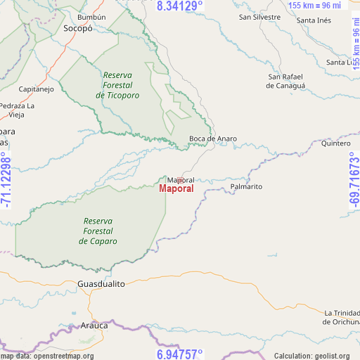
| Map corner | latitude | longitude |
|---|---|---|
| Upper-left | 8.34129°, | -71.12298° |
| Center: | 7.645°, | -70.41985° |
| Lower-right: | 6.94757°, | -69.71673° |
| Map W x H: | 155×155 km | = 96.3×96.3mi |
| max Lat: | 11.94788° ⇑93.9% North |
| Maporal: | 7.645° |
| min Lat: | ⇓6.1% South 1.92027° |
| min Long | Maporal | max Long |
| -72.55212° | -70.41985° | -60.99778° |
| W 28.5%⇐ | ⇒71.5% E |
Elevation
Elevation of Maporal is 115 m = 377 ft, and this is 265.6 m = 871 ft below average elevation for this country.
| Max E: |
2986 m = 9797 ft | 63.6% |
| Avg. | 380.6 m = 1249 ft | |
| Maporal | 115 m = 377 ft | |
Min E: |
-4 m = -13 ft | 36.4% |
See also: Venezuela elevation on elevation.city.
Geographical zone
Maporal is located in North Torrid zone (between Equator and Tropic of Cancer). Distance of Equator is 850 km =528.2 mi to South.| Distance of | km | miles | from Maporal |
|---|---|---|---|
| North Pole | 9157 | 5689.9 | to North |
| Arctic Circle | 6551.1 | 4070.7 | to North |
| Tropic Cancer | 1755.9 | 1091.1 | to North |
| Equator | 850 | 528.2 | to South |


Nearby cities:
15 places around Maporal: (largest is in red/bold)
• Bum Bum
79.9 km =49.6 mi,  331°
331°
• Capitanejo
76.2 km =47.3 mi,  302°
302°
• Chameta
73.7 km =45.8 mi,  313°
313°
• Ciudad Bolivia
80.5 km =50 mi,  348°
348°
• Curbatí
91.2 km =56.7 mi, 350°
• El Cantón
98.4 km =61.1 mi,  259°
259°
• El Real
99.5 km =61.8 mi,  27°
27°
• Guasdualito
56.5 km =35.1 mi,  217°
217°
• Pedraza La Vieja
76.7 km =47.7 mi,  293°
293°
• San Rafael de Canaguá
62.1 km =38.6 mi,  46°
46°
• San Silvestre
78 km =48.5 mi, 25°
• Santa Bárbara
85.6 km =53.2 mi,  282°
282°
• Santa Inés
89.5 km =55.6 mi,  39°
39°
• Santa Lucía
87.1 km =54.1 mi, 54°
• Socopó
78.7 km =48.9 mi, 325°
Sources, notices
• [Note1] Compared only with cities in Venezuela existing in our database
• [Src1] Map data: © OpenStreetMap contributors (CC-BY-SA)
• [Src2] Other city data from geonames.org with taken over terms of usage.
• [Src3] Geographical zone / Annual Mean Temperature by Robert A. Rohde @ Wikipedia
