Bích Động geodata
Bích Động (Bắc Giang) is a seat of a second-order administrative division; located in Vietnam in Asia/Ho_Chi_Minh (GMT+7) time zone. In our database, there are 94 cities with bigger population. Compared to other cities in Vietnam, 81.7% of cities are located further ↓South; 50.7% of cities are located further →East and 65.4% of cities have higher elevation than Bích Động. Note1


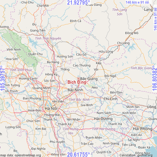
Bích Động GPS coordinates[2]
21° 16' 27.156" North, 106° 6' 2.484" East
| Map corner | latitude | longitude |
|---|---|---|
| Upper-left | 21.92795°, | 105.39757° |
| Center: | 21.27421°, | 106.10069° |
| Lower-right: | 20.61755°, | 106.80382° |
| Map W x H: | 145.7×145.7 km | = 90.5×90.5mi |
| max Lat: | 23.27841° ⇑18.3% North |
| Bích Động: | 21.27421° |
| min Lat: | ⇓81.7% South 8.65724° |
| min Long | Bích Động | max Long |
| 102.4579° | 106.10069° | 112.72541° |
| W 49.3%⇐ | ⇒50.7% E |
Elevation
Elevation of Bích Động is 9 m = 30 ft, and this is 120.5 m = 395 ft below average elevation for this country.
| Max E: |
1592 m = 5223 ft | 65.4% |
| Avg. | 129.5 m = 425 ft | |
| Bích Động | 9 m = 30 ft | |
Min E: |
-1 m = -3 ft | 34.6% |
See also: Vietnam elevation on elevation.city.
Geographical zone
Bích Động is located in North Torrid zone (between Equator and Tropic of Cancer). Distance of this Northern Tropic circle is 240.4 km =149.4 mi to North.| Distance of | km | miles | from Bích Động |
|---|---|---|---|
| North Pole | 7641.6 | 4748.3 | to North |
| Arctic Circle | 5035.7 | 3129 | to North |
| Tropic Cancer | 240.4 | 149.4 | to North |
| Equator | 2365.5 | 1469.9 | to South |


Nearby cities:
15 places around Bích Động: (largest is in red/bold)
• Bắc Giang
9.7 km =6 mi,  90°
90°
• Bắc Ninh
10.1 km =6.3 mi,  194°
194°
• Cao Thượng
12.9 km =8 mi,  13°
13°
• Chờ
17.5 km =10.9 mi,  239°
239°
• Cung Kiệm
11.5 km =7.1 mi,  147°
147°
• Cầu Gồ
22.7 km =14.1 mi, 6°
• Gia Bình
25.1 km =15.6 mi,  162°
162°
• Hương Sơn
24.3 km =15.1 mi,  328°
328°
• Hồ
23.5 km =14.6 mi,  183°
183°
• Lim
16.7 km =10.4 mi,  209°
209°
• Neo
17.3 km =10.7 mi,  118°
118°
• Phù Ninh
26.4 km =16.4 mi,  216°
216°
• Phố Mới
14.4 km =8.9 mi, 158°
• Sóc Sơn
26.1 km =16.2 mi,  266°
266°
• Thắng
15.1 km =9.4 mi,  306°
306°
Sources, notices
• [Note1] Compared only with cities in Vietnam existing in our database
• [Src1] Map data: © OpenStreetMap contributors (CC-BY-SA)
• [Src2] Other city data from geonames.org with taken over terms of usage.
• [Src3] Geographical zone / Annual Mean Temperature by Robert A. Rohde @ Wikipedia
