Chờ geodata
Chờ (Bắc Ninh) is a seat of a second-order administrative division; located in Vietnam in Asia/Ho_Chi_Minh (GMT+7) time zone. In our database, there are 94 cities with bigger population. Compared to other cities in Vietnam, 79.4% of cities are located further ↓South; 57.6% of cities are located further →East and 58.1% of cities have higher elevation than Chờ. Note1


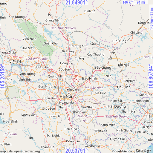
Chờ GPS coordinates[2]
21° 11' 41.676" North, 105° 57' 16.956" East
| Map corner | latitude | longitude |
|---|---|---|
| Upper-left | 21.84901°, | 105.25159° |
| Center: | 21.19491°, | 105.95471° |
| Lower-right: | 20.53791°, | 106.65784° |
| Map W x H: | 145.8×145.8 km | = 90.6×90.6mi |
| max Lat: | 23.27841° ⇑20.6% North |
| Chờ: | 21.19491° |
| min Lat: | ⇓79.4% South 8.65724° |
| min Long | Chờ | max Long |
| 102.4579° | 105.95471° | 112.72541° |
| W 42.4%⇐ | ⇒57.6% E |
Elevation
Elevation of Chờ is 11 m = 36 ft, and this is 118.5 m = 389 ft below average elevation for this country.
| Max E: |
1592 m = 5223 ft | 58.1% |
| Avg. | 129.5 m = 425 ft | |
| Chờ | 11 m = 36 ft | |
Min E: |
-1 m = -3 ft | 41.9% |
See also: Vietnam elevation on elevation.city.
Geographical zone
Chờ is located in North Torrid zone (between Equator and Tropic of Cancer). Distance of this Northern Tropic circle is 249.3 km =154.9 mi to North.| Distance of | km | miles | from Chờ |
|---|---|---|---|
| North Pole | 7650.4 | 4753.7 | to North |
| Arctic Circle | 5044.5 | 3134.5 | to North |
| Tropic Cancer | 249.3 | 154.9 | to North |
| Equator | 2356.7 | 1464.4 | to South |


Nearby cities:
15 places around Chờ: (largest is in red/bold)
• Bích Động
17.5 km =10.9 mi,  59°
59°
• Bắc Ninh
12.6 km =7.8 mi,  94°
94°
• Cung Kiệm
21.4 km =13.3 mi, 92°
• Hai BàTrưng
23 km =14.3 mi,  208°
208°
• Hanoi
22.3 km =13.9 mi, 211°
• Hoàn Kiếm
21.4 km =13.3 mi, 210°
• Hồ
20 km =12.4 mi,  137°
137°
• Lim
8.8 km =5.5 mi,  129°
129°
• Phù Ninh
12.4 km =7.7 mi,  182°
182°
• Phố Mới
20.9 km =13 mi,  102°
102°
• Sóc Sơn
13 km =8.1 mi,  302°
302°
• Thắng
18.1 km =11.2 mi,  9°
9°
• Trâu Quỳ
19.6 km =12.2 mi,  185°
185°
• Tây Hồ
20.5 km =12.7 mi,  226°
226°
• Đông Anh
12.5 km =7.8 mi,  240°
240°
Sources, notices
• [Note1] Compared only with cities in Vietnam existing in our database
• [Src1] Map data: © OpenStreetMap contributors (CC-BY-SA)
• [Src2] Other city data from geonames.org with taken over terms of usage.
• [Src3] Geographical zone / Annual Mean Temperature by Robert A. Rohde @ Wikipedia
