Sóc Sơn geodata
Sóc Sơn (Hanoi) is a seat of a second-order administrative division; located in Vietnam in Asia/Ho_Chi_Minh (GMT+7) time zone. In our database, there are 94 cities with bigger population. Compared to other cities in Vietnam, 81.1% of cities are located further ↓South; 61.3% of cities are located further →East and 55.8% of cities have lower elevation than Sóc Sơn. Note1


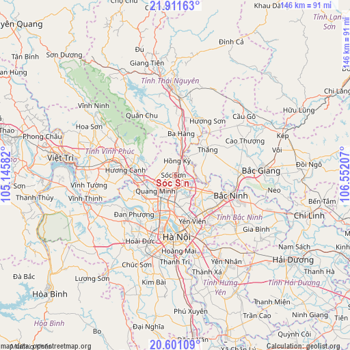
Sóc Sơn GPS coordinates[2]
21° 15' 28.152" North, 105° 50' 56.184" East
| Map corner | latitude | longitude |
|---|---|---|
| Upper-left | 21.91163°, | 105.14582° |
| Center: | 21.25782°, | 105.84894° |
| Lower-right: | 20.60109°, | 106.55207° |
| Map W x H: | 145.7×145.7 km | = 90.5×90.5mi |
| max Lat: | 23.27841° ⇑18.9% North |
| Sóc Sơn: | 21.25782° |
| min Lat: | ⇓81.1% South 8.65724° |
| min Long | Sóc Sơn | max Long |
| 102.4579° | 105.84894° | 112.72541° |
| W 38.7%⇐ | ⇒61.3% E |
Elevation
Elevation of Sóc Sơn is 18 m = 59 ft, and this is 111.5 m = 366 ft below average elevation for this country.
| Max E: |
1592 m = 5223 ft | 44.2% |
| Avg. | 129.5 m = 425 ft | |
| Sóc Sơn | 18 m = 59 ft | |
Min E: |
-1 m = -3 ft | 55.8% |
See also: Vietnam elevation on elevation.city.
Geographical zone
Sóc Sơn is located in North Torrid zone (between Equator and Tropic of Cancer). Distance of this Northern Tropic circle is 242.3 km =150.6 mi to North.| Distance of | km | miles | from Sóc Sơn |
|---|---|---|---|
| North Pole | 7643.4 | 4749.4 | to North |
| Arctic Circle | 5037.5 | 3130.2 | to North |
| Tropic Cancer | 242.3 | 150.6 | to North |
| Equator | 2363.6 | 1468.7 | to South |


Nearby cities:
15 places around Sóc Sơn: (largest is in red/bold)
• Bắc Ninh
24.9 km =15.5 mi,  108°
108°
• Chờ
13 km =8.1 mi,  122°
122°
• Cầu Diễn
25.8 km =16 mi,  199°
199°
• Cầu Giấy
25.6 km =15.9 mi,  191°
191°
• Hoàn Kiếm
25.5 km =15.8 mi,  179°
179°
• Hương Canh
21.1 km =13.1 mi,  276°
276°
• Lim
21.8 km =13.5 mi,  125°
125°
• Mê Linh
15.7 km =9.8 mi,  238°
238°
• Phù Ninh
22.1 km =13.7 mi,  151°
151°
• Phúc Yên
15.1 km =9.4 mi,  261°
261°
• Thắng
17.6 km =10.9 mi,  52°
52°
• Trôi
25.6 km =15.9 mi,  215°
215°
• Tây Hồ
21.4 km =13.3 mi, 190°
• Vĩnh Yên
25.9 km =16.1 mi, 282°
• Đông Anh
13.1 km =8.1 mi, 179°
Sources, notices
• [Note1] Compared only with cities in Vietnam existing in our database
• [Src1] Map data: © OpenStreetMap contributors (CC-BY-SA)
• [Src2] Other city data from geonames.org with taken over terms of usage.
• [Src3] Geographical zone / Annual Mean Temperature by Robert A. Rohde @ Wikipedia
