Plei Kần geodata
Plei Kần (Kon Tum) is a seat of a second-order administrative division; located in Vietnam in Asia/Ho_Chi_Minh (GMT+7) time zone. In our database, there are 94 cities with bigger population. Compared to other cities in Vietnam, 57.7% of cities are located further ↑North; 80.4% of cities are located further ←West and 94.6% of cities have lower elevation than Plei Kần. Note1


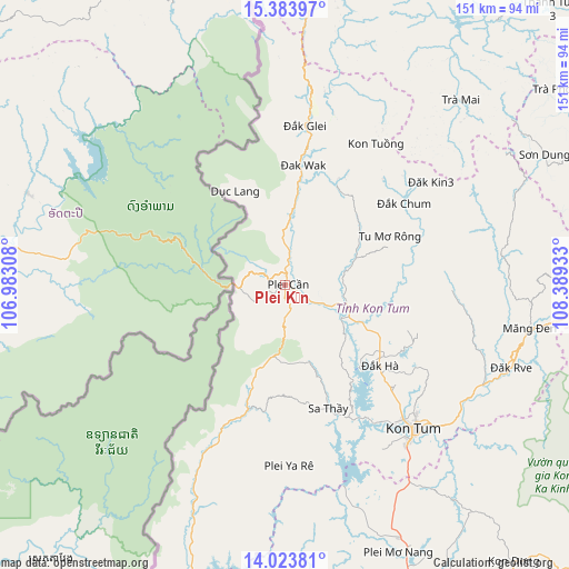
Plei Kần GPS coordinates[2]
14° 42' 17.82" North, 107° 41' 10.32" East
| Map corner | latitude | longitude |
|---|---|---|
| Upper-left | 15.38397°, | 106.98308° |
| Center: | 14.70495°, | 107.6862° |
| Lower-right: | 14.02381°, | 108.38933° |
| Map W x H: | 151.2×151.2 km | = 94×94mi |
| max Lat: | 23.27841° ⇑57.7% North |
| Plei Kần: | 14.70495° |
| min Lat: | ⇓42.3% South 8.65724° |
| min Long | Plei Kần | max Long |
| 102.4579° | 107.6862° | 112.72541° |
| W 80.4%⇐ | ⇒19.6% E |
Elevation
Elevation of Plei Kần is 663 m = 2175 ft, and this is 533.5 m = 1750 ft above average elevation for this country.
| Max E: |
1592 m = 5223 ft | 5.4% |
| Plei Kần | 663 m 2175 ft | |
| Avg. | 129.5 m = 425 ft | |
Min E: |
-1 m = -3 ft | 94.6% |
See also: Vietnam elevation on elevation.city.
Geographical zone
Plei Kần is located in North Torrid zone (between Equator and Tropic of Cancer). Distance of this Northern Tropic circle is 970.9 km =603.3 mi to North.| Distance of | km | miles | from Plei Kần |
|---|---|---|---|
| North Pole | 8372 | 5202.1 | to North |
| Arctic Circle | 5766.1 | 3582.9 | to North |
| Tropic Cancer | 970.9 | 603.3 | to North |
| Equator | 1635 | 1015.9 | to South |


Nearby cities:
15 places around Plei Kần: (largest is in red/bold)
• Ia Kha
84.3 km =52.4 mi,  168°
168°
• Khâm Đức
83.1 km =51.6 mi,  7°
7°
• Kon Tum
52.1 km =32.4 mi,  138°
138°
• Măng Đen
66.1 km =41.1 mi,  100°
100°
• Phú Hòa
73.8 km =45.9 mi,  155°
155°
• Pleiku
87.1 km =54.1 mi, 157°
• Sa Thầy
34.4 km =21.4 mi, 160°
• Sơn Hà
92.2 km =57.3 mi,  66°
66°
• Trà My
91 km =56.5 mi,  39°
39°
• Tây Trà
88.9 km =55.2 mi,  54°
54°
• Đăk Đoa
91.3 km =56.7 mi,  149°
149°
• Đắk Glei
42.7 km =26.5 mi, 7°
• Đắk Hà
33 km =20.5 mi,  130°
130°
• Đắk Rve
64.3 km =40 mi,  110°
110°
• Đắk Tô
17.1 km =10.6 mi, 106°
Sources, notices
• [Note1] Compared only with cities in Vietnam existing in our database
• [Src1] Map data: © OpenStreetMap contributors (CC-BY-SA)
• [Src2] Other city data from geonames.org with taken over terms of usage.
• [Src3] Geographical zone / Annual Mean Temperature by Robert A. Rohde @ Wikipedia
