Sơn Hà geodata
Sơn Hà (Quảng Ngãi Province) is a seat of a second-order administrative division; located in Vietnam in Asia/Ho_Chi_Minh (GMT+7) time zone. In our database, there are 94 cities with bigger population. Compared to other cities in Vietnam, 56.9% of cities are located further ↑North; 91.5% of cities are located further ←West and 72.6% of cities have lower elevation than Sơn Hà. Note1


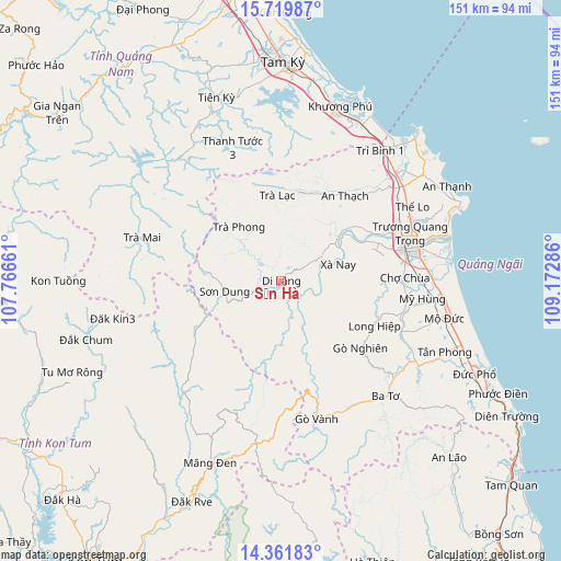
Sơn Hà GPS coordinates[2]
15° 2' 30.948" North, 108° 28' 11.028" East
| Map corner | latitude | longitude |
|---|---|---|
| Upper-left | 15.71987°, | 107.76661° |
| Center: | 15.04193°, | 108.46973° |
| Lower-right: | 14.36183°, | 109.17286° |
| Map W x H: | 151×151 km | = 93.8×93.8mi |
| max Lat: | 23.27841° ⇑56.9% North |
| Sơn Hà: | 15.04193° |
| min Lat: | ⇓43.1% South 8.65724° |
| min Long | Sơn Hà | max Long |
| 102.4579° | 108.46973° | 112.72541° |
| W 91.5%⇐ | ⇒8.5% E |
Elevation
Elevation of Sơn Hà is 68 m = 223 ft, and this is 61.5 m = 202 ft below average elevation for this country.
| Max E: |
1592 m = 5223 ft | 27.4% |
| Avg. | 129.5 m = 425 ft | |
| Sơn Hà | 68 m = 223 ft | |
Min E: |
-1 m = -3 ft | 72.6% |
See also: Vietnam elevation on elevation.city.
Geographical zone
Sơn Hà is located in North Torrid zone (between Equator and Tropic of Cancer). Distance of this Northern Tropic circle is 933.4 km =580 mi to North.| Distance of | km | miles | from Sơn Hà |
|---|---|---|---|
| North Pole | 8334.6 | 5178.9 | to North |
| Arctic Circle | 5728.7 | 3559.6 | to North |
| Tropic Cancer | 933.4 | 580 | to North |
| Equator | 1672.5 | 1039.2 | to South |


Nearby cities:
15 places around Sơn Hà: (largest is in red/bold)
• Ba Tơ
41.9 km =26 mi,  137°
137°
• Bình Sơn
42.3 km =26.3 mi,  47°
47°
• Minh Long
27.9 km =17.3 mi,  115°
115°
• Măng Đen
52.7 km =32.7 mi,  201°
201°
• Mộ Đức
45.7 km =28.4 mi,  102°
102°
• Nghĩa Hành
33 km =20.5 mi,  89°
89°
• Núi Thành
47.9 km =29.8 mi,  25°
25°
• Phú Ninh
57.4 km =35.7 mi,  353°
353°
• Quảng Ngãi
35.7 km =22.2 mi,  75°
75°
• Sơn Tịnh
37.3 km =23.2 mi,  69°
69°
• Tiên Phước
52.6 km =32.7 mi,  340°
340°
• Trà Bồng
24.3 km =15.1 mi,  12°
12°
• Trà My
42.5 km =26.4 mi,  321°
321°
• Tây Trà
18.4 km =11.4 mi, 320°
• Tư Nghĩa
38.5 km =23.9 mi, 82°
Sources, notices
• [Note1] Compared only with cities in Vietnam existing in our database
• [Src1] Map data: © OpenStreetMap contributors (CC-BY-SA)
• [Src2] Other city data from geonames.org with taken over terms of usage.
• [Src3] Geographical zone / Annual Mean Temperature by Robert A. Rohde @ Wikipedia
