Cát Bà geodata
Cát Bà (Haiphong) is a populated place; located in Vietnam in Asia/Ho_Chi_Minh (GMT+7) time zone. With population of 30,000 people, there are 76 cities with bigger population in this country. Compared to other cities in Vietnam, 67.7% of cities are located further ↓South; 74.7% of cities are located further ←West and 61% of cities have lower elevation than Cát Bà. Note1


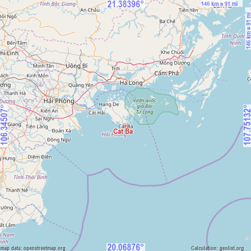
Cát Bà GPS coordinates[2]
20° 43' 40.044" North, 107° 2' 53.484" East
| Map corner | latitude | longitude |
|---|---|---|
| Upper-left | 21.38396°, | 106.34507° |
| Center: | 20.72779°, | 107.04819° |
| Lower-right: | 20.06876°, | 107.75132° |
| Map W x H: | 146.2×146.2 km | = 90.8×90.8mi |
| max Lat: | 23.27841° ⇑32.3% North |
| Cát Bà: | 20.72779° |
| min Lat: | ⇓67.7% South 8.65724° |
| min Long | Cát Bà | max Long |
| 102.4579° | 107.04819° | 112.72541° |
| W 74.7%⇐ | ⇒25.3% E |
Elevation
Elevation of Cát Bà is 24 m = 79 ft, and this is 105.5 m = 346 ft below average elevation for this country.
| Max E: |
1592 m = 5223 ft | 39% |
| Avg. | 129.5 m = 425 ft | |
| Cát Bà | 24 m = 79 ft | |
Min E: |
-1 m = -3 ft | 61% |
See also: Vietnam elevation on elevation.city.
Geographical zone
Cát Bà is located in North Torrid zone (between Equator and Tropic of Cancer). Distance of this Northern Tropic circle is 301.2 km =187.2 mi to North.| Distance of | km | miles | from Cát Bà |
|---|---|---|---|
| North Pole | 7702.3 | 4786 | to North |
| Arctic Circle | 5096.5 | 3166.8 | to North |
| Tropic Cancer | 301.2 | 187.2 | to North |
| Equator | 2304.7 | 1432.1 | to South |


Nearby cities:
15 places around Cát Bà: (largest is in red/bold)
• An Dương
47.7 km =29.6 mi,  288°
288°
• An Lão
52.3 km =32.5 mi,  281°
281°
• Cẩm Phả
39.1 km =24.3 mi,  36°
36°
• Cẩm Phả Mines
41.4 km =25.7 mi, 39°
• Giemdiem
53.3 km =33.1 mi,  249°
249°
• Haiphong
40.9 km =25.4 mi, 291°
• Hạ Long
24.9 km =15.5 mi,  6°
6°
• Kinh Môn
58.9 km =36.6 mi,  299°
299°
• Núi Đèo
44.1 km =27.4 mi, 298°
• Núi Đối
39.5 km =24.5 mi,  273°
273°
• Phú Thái
61.8 km =38.4 mi, 295°
• Quảng Yên
34.9 km =21.7 mi,  313°
313°
• Thành Phố Uông Bí
44.7 km =27.8 mi,  319°
319°
• Tiên Lãng
51.4 km =31.9 mi, 269°
• Trới
34.3 km =21.3 mi,  350°
350°
Sources, notices
• [Note1] Compared only with cities in Vietnam existing in our database
• [Src1] Map data: © OpenStreetMap contributors (CC-BY-SA)
• [Src2] Other city data from geonames.org with taken over terms of usage.
• [Src3] Geographical zone / Annual Mean Temperature by Robert A. Rohde @ Wikipedia
