Hạ Long geodata
Hạ Long (Quảng Ninh) is a seat of a first-order administrative division; located in Vietnam in Asia/Ho_Chi_Minh (GMT+7) time zone. With population of 148,066 people, there are 22 cities with bigger population in this country. Compared to other cities in Vietnam, 73.1% of cities are located further ↓South; 75% of cities are located further ←West and 71.9% of cities have higher elevation than Hạ Long. Note1


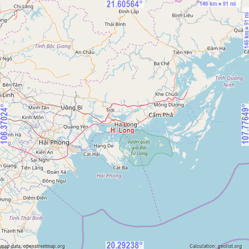
Hạ Long GPS coordinates[2]
20° 57' 1.62" North, 107° 4' 24.096" East
| Map corner | latitude | longitude |
|---|---|---|
| Upper-left | 21.60564°, | 106.37024° |
| Center: | 20.95045°, | 107.07336° |
| Lower-right: | 20.29238°, | 107.77649° |
| Map W x H: | 146×146 km | = 90.7×90.7mi |
| max Lat: | 23.27841° ⇑26.9% North |
| Hạ Long: | 20.95045° |
| min Lat: | ⇓73.1% South 8.65724° |
| min Long | Hạ Long | max Long |
| 102.4579° | 107.07336° | 112.72541° |
| W 75%⇐ | ⇒25% E |
Elevation
Elevation of Hạ Long is 8 m = 26 ft, and this is 121.5 m = 399 ft below average elevation for this country.
| Max E: |
1592 m = 5223 ft | 71.9% |
| Avg. | 129.5 m = 425 ft | |
| Hạ Long | 8 m = 26 ft | |
Min E: |
-1 m = -3 ft | 28.1% |
See also: Hạ Long elevation on elevation.city.
Geographical zone
Hạ Long is located in North Torrid zone (between Equator and Tropic of Cancer). Distance of this Northern Tropic circle is 276.4 km =171.7 mi to North.| Distance of | km | miles | from Hạ Long |
|---|---|---|---|
| North Pole | 7677.6 | 4770.6 | to North |
| Arctic Circle | 5071.7 | 3151.4 | to North |
| Tropic Cancer | 276.4 | 171.7 | to North |
| Equator | 2329.5 | 1447.5 | to South |


Nearby cities:
15 places around Hạ Long: (largest is in red/bold)
• An Châu
48.6 km =30.2 mi,  331°
331°
• An Dương
48.7 km =30.3 mi,  258°
258°
• An Lão
55.6 km =34.5 mi, 255°
• Cát Bà
24.9 km =15.5 mi,  186°
186°
• Cẩm Phả
21.8 km =13.5 mi,  72°
72°
• Cẩm Phả Mines
24.7 km =15.3 mi, 72°
• Haiphong
41.6 km =25.8 mi, 256°
• Kinh Môn
54 km =33.6 mi,  274°
274°
• Núi Đèo
41.6 km =25.8 mi, 264°
• Núi Đối
47.5 km =29.5 mi,  242°
242°
• Phú Thái
58.6 km =36.4 mi, 271°
• Quảng Yên
28.1 km =17.5 mi, 268°
• Thành Phố Uông Bí
32.8 km =20.4 mi,  286°
286°
• Tiên Lãng
59.5 km =37 mi,  245°
245°
• Trới
12.4 km =7.7 mi,  316°
316°
Sources, notices
• [Note1] Compared only with cities in Vietnam existing in our database
• [Src1] Map data: © OpenStreetMap contributors (CC-BY-SA)
• [Src2] Other city data from geonames.org with taken over terms of usage.
• [Src3] Geographical zone / Annual Mean Temperature by Robert A. Rohde @ Wikipedia
