Mỹ Thọ geodata
Mỹ Thọ (Đồng Tháp) is a seat of a second-order administrative division; located in Vietnam in Asia/Ho_Chi_Minh (GMT+7) time zone. In our database, there are 94 cities with bigger population. Compared to other cities in Vietnam, 85.2% of cities are located further ↑North; 68.7% of cities are located further →East and 75% of cities have higher elevation than Mỹ Thọ. Note1


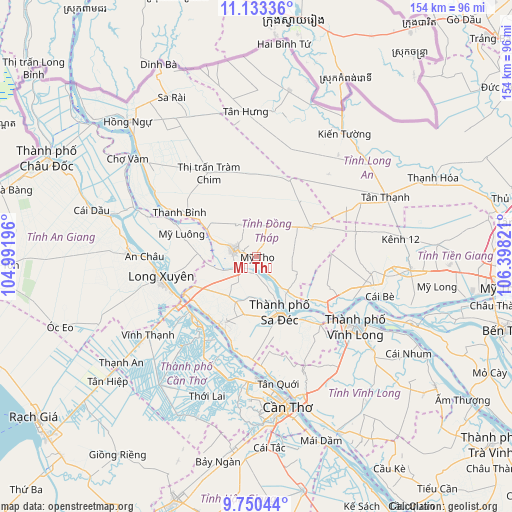
Mỹ Thọ GPS coordinates[2]
10° 26' 33.612" North, 105° 41' 42.288" East
| Map corner | latitude | longitude |
|---|---|---|
| Upper-left | 11.13336°, | 104.99196° |
| Center: | 10.44267°, | 105.69508° |
| Lower-right: | 9.75044°, | 106.39821° |
| Map W x H: | 153.8×153.8 km | = 95.6×95.6mi |
| max Lat: | 23.27841° ⇑85.2% North |
| Mỹ Thọ: | 10.44267° |
| min Lat: | ⇓14.8% South 8.65724° |
| min Long | Mỹ Thọ | max Long |
| 102.4579° | 105.69508° | 112.72541° |
| W 31.3%⇐ | ⇒68.7% E |
Elevation
Elevation of Mỹ Thọ is 7 m = 23 ft, and this is 122.5 m = 402 ft below average elevation for this country.
| Max E: |
1592 m = 5223 ft | 75% |
| Avg. | 129.5 m = 425 ft | |
| Mỹ Thọ | 7 m = 23 ft | |
Min E: |
-1 m = -3 ft | 25% |
See also: Vietnam elevation on elevation.city.
Geographical zone
Mỹ Thọ is located in North Torrid zone (between Equator and Tropic of Cancer). Distance of Equator is 1161.1 km =721.5 mi to South.| Distance of | km | miles | from Mỹ Thọ |
|---|---|---|---|
| North Pole | 8845.9 | 5496.6 | to North |
| Arctic Circle | 6240.1 | 3877.4 | to North |
| Tropic Cancer | 1444.8 | 897.8 | to North |
| Equator | 1161.1 | 721.5 | to South |


Nearby cities:
15 places around Mỹ Thọ: (largest is in red/bold)
• An Châu
33.8 km =21 mi,  270°
270°
• An Hòa
17.1 km =10.6 mi,  161°
161°
• Cao Lãnh
7.1 km =4.4 mi,  285°
285°
• Chợ Mới
34 km =21.1 mi, 290°
• Cái Tàu Hạ
28 km =17.4 mi,  136°
136°
• Lai Vung
17.7 km =11 mi,  191°
191°
• Long Xuyên
29.1 km =18.1 mi,  257°
257°
• Lấp Vò
21.2 km =13.2 mi,  244°
244°
• Sa Dec
18.2 km =11.3 mi, 158°
• Thanh Bình
26.6 km =16.5 mi,  299°
299°
• Thị Trấn Tân Thành
23.6 km =14.7 mi,  208°
208°
• Thốt Nốt
25.9 km =16.1 mi,  222°
222°
• Tràm Chim
29 km =18 mi,  330°
330°
• Vĩnh Long
36.9 km =22.9 mi,  124°
124°
• Ô Môn
37.8 km =23.5 mi, 191°
Sources, notices
• [Note1] Compared only with cities in Vietnam existing in our database
• [Src1] Map data: © OpenStreetMap contributors (CC-BY-SA)
• [Src2] Other city data from geonames.org with taken over terms of usage.
• [Src3] Geographical zone / Annual Mean Temperature by Robert A. Rohde @ Wikipedia
