Thạnh Phú geodata
Thạnh Phú (Bến Tre) is a seat of a second-order administrative division; located in Vietnam in Asia/Ho_Chi_Minh (GMT+7) time zone. In our database, there are 94 cities with bigger population. Compared to other cities in Vietnam, 92.8% of cities are located further ↑North; 63% of cities are located further ←West and 92.5% of cities have higher elevation than Thạnh Phú. Note1


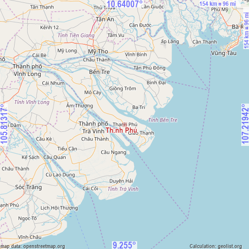
Thạnh Phú GPS coordinates[2]
9° 56' 53.772" North, 106° 30' 58.644" East
| Map corner | latitude | longitude |
|---|---|---|
| Upper-left | 10.64007°, | 105.81317° |
| Center: | 9.94827°, | 106.51629° |
| Lower-right: | 9.255°, | 107.21942° |
| Map W x H: | 154×154 km | = 95.7×95.7mi |
| max Lat: | 23.27841° ⇑92.8% North |
| Thạnh Phú: | 9.94827° |
| min Lat: | ⇓7.2% South 8.65724° |
| min Long | Thạnh Phú | max Long |
| 102.4579° | 106.51629° | 112.72541° |
| W 63%⇐ | ⇒37% E |
Elevation
Elevation of Thạnh Phú is 4 m = 13 ft, and this is 125.5 m = 412 ft below average elevation for this country.
| Max E: |
1592 m = 5223 ft | 92.5% |
| Avg. | 129.5 m = 425 ft | |
| Thạnh Phú | 4 m = 13 ft | |
Min E: |
-1 m = -3 ft | 7.5% |
See also: Vietnam elevation on elevation.city.
Geographical zone
Thạnh Phú is located in North Torrid zone (between Equator and Tropic of Cancer). Distance of Equator is 1106.1 km =687.3 mi to South.| Distance of | km | miles | from Thạnh Phú |
|---|---|---|---|
| North Pole | 8900.9 | 5530.8 | to North |
| Arctic Circle | 6295 | 3911.5 | to North |
| Tropic Cancer | 1499.8 | 931.9 | to North |
| Equator | 1106.1 | 687.3 | to South |


Nearby cities:
15 places around Thạnh Phú: (largest is in red/bold)
• Ba Tri
13.4 km =8.3 mi,  37°
37°
• Bình Đại
33 km =20.5 mi, 35°
• Bến Tre
36 km =22.4 mi,  334°
334°
• Châu Thành
20.3 km =12.6 mi,  244°
244°
• Châu Thành
42.9 km =26.7 mi,  336°
336°
• Chợ Gạo
45 km =28 mi,  352°
352°
• Duyên Hải
34.9 km =21.7 mi,  184°
184°
• Giồng Trôm
22.5 km =14 mi,  357°
357°
• Mỏ Cày
28.6 km =17.8 mi,  316°
316°
• Tiểu Cần
38.8 km =24.1 mi,  246°
246°
• Trà Cú
39.7 km =24.7 mi,  225°
225°
• Trà Vinh
19.1 km =11.9 mi,  269°
269°
• Vĩnh Bình
44.7 km =27.8 mi,  9°
9°
• Vũng Liêm
39.8 km =24.7 mi,  294°
294°
• Ấp Tân Ngãi
40.7 km =25.3 mi, 321°
Sources, notices
• [Note1] Compared only with cities in Vietnam existing in our database
• [Src1] Map data: © OpenStreetMap contributors (CC-BY-SA)
• [Src2] Other city data from geonames.org with taken over terms of usage.
• [Src3] Geographical zone / Annual Mean Temperature by Robert A. Rohde @ Wikipedia
