Chợ Gạo geodata
Chợ Gạo (Tiền Giang) is a seat of a second-order administrative division; located in Vietnam in Asia/Ho_Chi_Minh (GMT+7) time zone. In our database, there are 94 cities with bigger population. Compared to other cities in Vietnam, 86.5% of cities are located further ↑North; 61.5% of cities are located further ←West and 71.9% of cities have higher elevation than Chợ Gạo. Note1


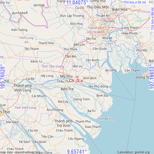
Chợ Gạo GPS coordinates[2]
10° 20' 59.424" North, 106° 27' 48.24" East
| Map corner | latitude | longitude |
|---|---|---|
| Upper-left | 11.04075°, | 105.76028° |
| Center: | 10.34984°, | 106.4634° |
| Lower-right: | 9.65741°, | 107.16653° |
| Map W x H: | 153.8×153.8 km | = 95.6×95.6mi |
| max Lat: | 23.27841° ⇑86.5% North |
| Chợ Gạo: | 10.34984° |
| min Lat: | ⇓13.5% South 8.65724° |
| min Long | Chợ Gạo | max Long |
| 102.4579° | 106.4634° | 112.72541° |
| W 61.5%⇐ | ⇒38.5% E |
Elevation
Elevation of Chợ Gạo is 8 m = 26 ft, and this is 121.5 m = 399 ft below average elevation for this country.
| Max E: |
1592 m = 5223 ft | 71.9% |
| Avg. | 129.5 m = 425 ft | |
| Chợ Gạo | 8 m = 26 ft | |
Min E: |
-1 m = -3 ft | 28.1% |
See also: Vietnam elevation on elevation.city.
Geographical zone
Chợ Gạo is located in North Torrid zone (between Equator and Tropic of Cancer). Distance of Equator is 1150.8 km =715.1 mi to South.| Distance of | km | miles | from Chợ Gạo |
|---|---|---|---|
| North Pole | 8856.3 | 5503 | to North |
| Arctic Circle | 6250.4 | 3883.8 | to North |
| Tropic Cancer | 1455.1 | 904.2 | to North |
| Equator | 1150.8 | 715.1 | to South |


Nearby cities:
15 places around Chợ Gạo: (largest is in red/bold)
• Bình Đại
30.7 km =19.1 mi,  125°
125°
• Bến Tre
15.4 km =9.6 mi,  218°
218°
• Châu Thành
12.8 km =8 mi,  245°
245°
• Cần Đước
23.4 km =14.5 mi,  40°
40°
• Giồng Trôm
22.7 km =14.1 mi,  168°
168°
• Mỏ Cày
27.9 km =17.3 mi,  210°
210°
• Mỹ Tho
11.4 km =7.1 mi,  275°
275°
• Thủ Thừa
28.9 km =18 mi,  346°
346°
• Tân An
21.4 km =13.3 mi, 345°
• Tân Hiệp
17.1 km =10.6 mi,  310°
310°
• Tân Hòa
27.3 km =17 mi,  97°
97°
• Tân Trụ
18.7 km =11.6 mi,  14°
14°
• Tầm Vu
10.2 km =6.3 mi,  2°
2°
• Vĩnh Bình
12.8 km =8 mi,  92°
92°
• Ấp Tân Ngãi
23.6 km =14.7 mi,  236°
236°
Sources, notices
• [Note1] Compared only with cities in Vietnam existing in our database
• [Src1] Map data: © OpenStreetMap contributors (CC-BY-SA)
• [Src2] Other city data from geonames.org with taken over terms of usage.
• [Src3] Geographical zone / Annual Mean Temperature by Robert A. Rohde @ Wikipedia
