Vũng Liêm geodata
Vũng Liêm (Vĩnh Long) is a seat of a second-order administrative division; located in Vietnam in Asia/Ho_Chi_Minh (GMT+7) time zone. In our database, there are 94 cities with bigger population. Compared to other cities in Vietnam, 90.9% of cities are located further ↑North; 53% of cities are located further ←West and 87.1% of cities have higher elevation than Vũng Liêm. Note1


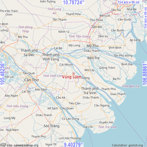
Vũng Liêm GPS coordinates[2]
10° 5' 44.736" North, 106° 11' 7.728" East
| Map corner | latitude | longitude |
|---|---|---|
| Upper-left | 10.78724°, | 105.48236° |
| Center: | 10.09576°, | 106.18548° |
| Lower-right: | 9.40279°, | 106.88861° |
| Map W x H: | 153.9×153.9 km | = 95.6×95.6mi |
| max Lat: | 23.27841° ⇑90.9% North |
| Vũng Liêm: | 10.09576° |
| min Lat: | ⇓9.1% South 8.65724° |
| min Long | Vũng Liêm | max Long |
| 102.4579° | 106.18548° | 112.72541° |
| W 53%⇐ | ⇒47% E |
Elevation
Elevation of Vũng Liêm is 5 m = 16 ft, and this is 124.5 m = 408 ft below average elevation for this country.
| Max E: |
1592 m = 5223 ft | 87.1% |
| Avg. | 129.5 m = 425 ft | |
| Vũng Liêm | 5 m = 16 ft | |
Min E: |
-1 m = -3 ft | 12.9% |
See also: Vietnam elevation on elevation.city.
Geographical zone
Vũng Liêm is located in North Torrid zone (between Equator and Tropic of Cancer). Distance of Equator is 1122.5 km =697.5 mi to South.| Distance of | km | miles | from Vũng Liêm |
|---|---|---|---|
| North Pole | 8884.5 | 5520.6 | to North |
| Arctic Circle | 6278.6 | 3901.3 | to North |
| Tropic Cancer | 1483.4 | 921.7 | to North |
| Equator | 1122.5 | 697.5 | to South |


Nearby cities:
15 places around Vũng Liêm: (largest is in red/bold)
• Bến Tre
26.4 km =16.4 mi,  52°
52°
• Châu Thành
29.6 km =18.4 mi,  39°
39°
• Châu Thành
30.9 km =19.2 mi,  144°
144°
• Chợ Lách
19.7 km =12.2 mi,  338°
338°
• Cái Nhum
12 km =7.5 mi,  316°
316°
• Cầu Kè
28.7 km =17.8 mi,  209°
209°
• Long Hồ
21.8 km =13.5 mi,  299°
299°
• Mỏ Cày
16.9 km =10.5 mi,  75°
75°
• Mỹ Tho
35 km =21.7 mi,  33°
33°
• Tam Bình
21 km =13 mi,  255°
255°
• Tiểu Cần
31.6 km =19.6 mi,  178°
178°
• Trà Vinh
23.8 km =14.8 mi,  133°
133°
• Trà Ôn
32.5 km =20.2 mi,  242°
242°
• Vĩnh Long
29.2 km =18.1 mi,  306°
306°
• Ấp Tân Ngãi
18.7 km =11.6 mi, 34°
Sources, notices
• [Note1] Compared only with cities in Vietnam existing in our database
• [Src1] Map data: © OpenStreetMap contributors (CC-BY-SA)
• [Src2] Other city data from geonames.org with taken over terms of usage.
• [Src3] Geographical zone / Annual Mean Temperature by Robert A. Rohde @ Wikipedia
