Ấp Tân Ngãi geodata
Ấp Tân Ngãi (Bến Tre) is a populated place; located in Vietnam in Asia/Ho_Chi_Minh (GMT+7) time zone. With population of 8,887 people, there are 89 cities with bigger population in this country. Compared to other cities in Vietnam, 89.1% of cities are located further ↑North; 55.5% of cities are located further ←West and 87.1% of cities have higher elevation than Ấp Tân Ngãi. Note1


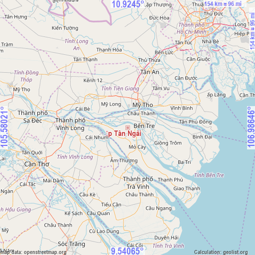
Ấp Tân Ngãi GPS coordinates[2]
10° 13' 59.988" North, 106° 16' 59.988" East
| Map corner | latitude | longitude |
|---|---|---|
| Upper-left | 10.9245°, | 105.58021° |
| Center: | 10.23333°, | 106.28333° |
| Lower-right: | 9.54065°, | 106.98646° |
| Map W x H: | 153.9×153.9 km | = 95.6×95.6mi |
| max Lat: | 23.27841° ⇑89.1% North |
| Ấp Tân Ngãi: | 10.23333° |
| min Lat: | ⇓10.9% South 8.65724° |
| min Long | Ấp Tân Ngãi | max Long |
| 102.4579° | 106.28333° | 112.72541° |
| W 55.5%⇐ | ⇒44.5% E |
Elevation
Elevation of Ấp Tân Ngãi is 5 m = 16 ft, and this is 124.5 m = 408 ft below average elevation for this country.
| Max E: |
1592 m = 5223 ft | 87.1% |
| Avg. | 129.5 m = 425 ft | |
| Ấp Tân Ngãi | 5 m = 16 ft | |
Min E: |
-1 m = -3 ft | 12.9% |
See also: Vietnam elevation on elevation.city.
Geographical zone
Ấp Tân Ngãi is located in North Torrid zone (between Equator and Tropic of Cancer). Distance of Equator is 1137.8 km =707 mi to South.| Distance of | km | miles | from Ấp Tân Ngãi |
|---|---|---|---|
| North Pole | 8869.2 | 5511.1 | to North |
| Arctic Circle | 6263.3 | 3891.8 | to North |
| Tropic Cancer | 1468.1 | 912.2 | to North |
| Equator | 1137.8 | 707 | to South |


Nearby cities:
15 places around Ấp Tân Ngãi: (largest is in red/bold)
• Bến Tre
10.2 km =6.3 mi,  84°
84°
• Châu Thành
11 km =6.8 mi,  46°
46°
• Chợ Gạo
23.6 km =14.7 mi,  56°
56°
• Chợ Lách
18.2 km =11.3 mi,  279°
279°
• Cái Nhum
20 km =12.4 mi,  250°
250°
• Giồng Trôm
26.1 km =16.2 mi,  110°
110°
• Long Hồ
30 km =18.6 mi,  261°
261°
• Mỏ Cày
12.5 km =7.8 mi,  153°
153°
• Mỹ Phước
28.9 km =18 mi,  339°
339°
• Mỹ Tho
16.4 km =10.2 mi,  30°
30°
• Trà Vinh
32.5 km =20.2 mi,  168°
168°
• Tân Hiệp
24.9 km =15.5 mi,  15°
15°
• Tầm Vu
30.7 km =19.1 mi,  41°
41°
• Vĩnh Long
34.1 km =21.2 mi,  273°
273°
• Vũng Liêm
18.7 km =11.6 mi,  214°
214°
Sources, notices
• [Note1] Compared only with cities in Vietnam existing in our database
• [Src1] Map data: © OpenStreetMap contributors (CC-BY-SA)
• [Src2] Other city data from geonames.org with taken over terms of usage.
• [Src3] Geographical zone / Annual Mean Temperature by Robert A. Rohde @ Wikipedia
