Mỏ Cày geodata
Mỏ Cày (Bến Tre) is a seat of a second-order administrative division; located in Vietnam in Asia/Ho_Chi_Minh (GMT+7) time zone. In our database, there are 94 cities with bigger population. Compared to other cities in Vietnam, 90.4% of cities are located further ↑North; 57.3% of cities are located further ←West and 87.1% of cities have higher elevation than Mỏ Cày. Note1


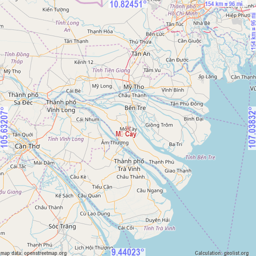
Mỏ Cày GPS coordinates[2]
10° 7' 59.232" North, 106° 20' 6.684" East
| Map corner | latitude | longitude |
|---|---|---|
| Upper-left | 10.82451°, | 105.63207° |
| Center: | 10.13312°, | 106.33519° |
| Lower-right: | 9.44023°, | 107.03832° |
| Map W x H: | 153.9×153.9 km | = 95.6×95.6mi |
| max Lat: | 23.27841° ⇑90.4% North |
| Mỏ Cày: | 10.13312° |
| min Lat: | ⇓9.6% South 8.65724° |
| min Long | Mỏ Cày | max Long |
| 102.4579° | 106.33519° | 112.72541° |
| W 57.3%⇐ | ⇒42.7% E |
Elevation
Elevation of Mỏ Cày is 5 m = 16 ft, and this is 124.5 m = 408 ft below average elevation for this country.
| Max E: |
1592 m = 5223 ft | 87.1% |
| Avg. | 129.5 m = 425 ft | |
| Mỏ Cày | 5 m = 16 ft | |
Min E: |
-1 m = -3 ft | 12.9% |
See also: Vietnam elevation on elevation.city.
Geographical zone
Mỏ Cày is located in North Torrid zone (between Equator and Tropic of Cancer). Distance of Equator is 1126.7 km =700.1 mi to South.| Distance of | km | miles | from Mỏ Cày |
|---|---|---|---|
| North Pole | 8880.4 | 5518 | to North |
| Arctic Circle | 6274.5 | 3898.8 | to North |
| Tropic Cancer | 1479.2 | 919.1 | to North |
| Equator | 1126.7 | 700.1 | to South |


Nearby cities:
15 places around Mỏ Cày: (largest is in red/bold)
• Ba Tri
29.6 km =18.4 mi,  109°
109°
• Bến Tre
12.8 km =8 mi,  20°
20°
• Châu Thành
18.8 km =11.7 mi,  7°
7°
• Châu Thành
29.3 km =18.2 mi,  176°
176°
• Chợ Gạo
27.9 km =17.3 mi,  30°
30°
• Chợ Lách
27.6 km =17.1 mi,  300°
300°
• Cái Nhum
25 km =15.5 mi,  280°
280°
• Giồng Trôm
18.8 km =11.7 mi,  84°
84°
• Mỹ Tho
25.4 km =15.8 mi, 6°
• Thạnh Phú
28.6 km =17.8 mi,  136°
136°
• Trà Vinh
20.7 km =12.9 mi, 177°
• Tân Hiệp
35.1 km =21.8 mi,  1°
1°
• Vĩnh Bình
35.7 km =22.2 mi,  48°
48°
• Vũng Liêm
16.9 km =10.5 mi,  255°
255°
• Ấp Tân Ngãi
12.5 km =7.8 mi,  333°
333°
Sources, notices
• [Note1] Compared only with cities in Vietnam existing in our database
• [Src1] Map data: © OpenStreetMap contributors (CC-BY-SA)
• [Src2] Other city data from geonames.org with taken over terms of usage.
• [Src3] Geographical zone / Annual Mean Temperature by Robert A. Rohde @ Wikipedia
